
Google’s story began with text-based search and was quickly followed by digital maps. These simple innovations ushered in the company’s mission to organize the world’s information. But as Google ventures further from its roots into mobile operating systems (Android), video (youtube), social media (Google+), smartphone hardware (through its purchase of Motorola’s mobile business), augmented reality (Google Glass), Web browsers (Chrome) and notebook hardware (Chromebook) what of its core mapping service? And is global domination all that it’s cracked up to be?
From the NYT:
Fifty-five miles and three days down the Colorado River from the put-in at Lee’s Ferry, near the Utah-Arizona border, the two rafts in our little flotilla suddenly encountered a storm. It sneaked up from behind, preceded by only a cool breeze. With the canyon walls squeezing the sky to a ribbon of blue, we didn’t see the thunderhead until it was nearly on top of us.
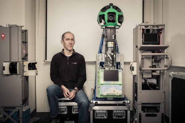
I was seated in the front of the lead raft. Pole position meant taking a dunk through the rapids, but it also put me next to Luc Vincent, the expedition’s leader. Vincent is the man responsible for all the imagery in Google’s online maps. He’s in charge of everything from choosing satellite pictures to deploying Google’s planes around the world to sending its camera-equipped cars down every road to even this, a float through the Grand Canyon. The raft trip was a mapping expedition that was also serving as a celebration: Google Maps had just introduced a major redesign, and the outing was a way of rewarding some of the team’s members.
Vincent wore a black T-shirt with the eagle-globe-and-anchor insignia of the United States Marine Corps on his chest and the slogan “Pain is weakness leaving the body” across his back. Though short in stature, he has the upper-body strength of an avid rock climber. He chose to get his Ph.D. in computer vision, he told me, because the lab happened to be close to Fontainebleau — the famous climbing spot in France. While completing his postdoc at the Harvard Robotics Lab, he led a successful expedition up Denali, the highest peak in North America.
A Frenchman who has lived half his 49 years in the United States, Vincent was never in the Marines. But he is a leader in a new great game: the Internet land grab, which can be reduced to three key battles over three key conceptual territories. What came first, conquered by Google’s superior search algorithms. Who was next, and Facebook was the victor. But where, arguably the biggest prize of all, has yet to be completely won.
Where-type questions — the kind that result in a little map popping up on the search-results page — account for some 20 percent of all Google queries done from the desktop. But ultimately more important by far is location-awareness, the sort of geographical information that our phones and other mobile devices already require in order to function. In the future, such location-awareness will be built into more than just phones. All of our stuff will know where it is — and that awareness will imbue the real world with some of the power of the virtual. Your house keys will tell you that they’re still on your desk at work. Your tools will remind you that they were lent to a friend. And your car will be able to drive itself on an errand to retrieve both your keys and your tools.
While no one can say exactly how we will get from the current moment to that Jetsonian future, one thing for sure can be said about location-awareness: maps are required. Tomorrow’s map, integrally connected to everything that moves (the keys, the tools, the car), will be so fundamental to their operation that the map will, in effect, be their operating system. A map is to location-awareness as Windows is to a P.C. And as the history of Microsoft makes clear, a company that controls the operating system controls just about everything. So the competition to make the best maps, the thinking goes, is more than a struggle over who dominates the trillion-dollar smartphone market; it’s a contest over the future itself.
Google was relatively late to this territory. Its map was only a few months old when it was featured at Tim O’Reilly’s inaugural Where 2.0 conference in 2005. O’Reilly is a publisher and a well-known visionary in Silicon Valley who is convinced that the Internet is evolving into a single vast, shared computer, one of whose most important individual functions, or subroutines, is location-awareness.
Google’s original map was rudimentary, essentially a digitized road atlas. Like the maps from Microsoft and Yahoo, it used licensed data, and areas outside the United States and Europe were represented as blue emptiness. Google’s innovation was the web interface: its map was dragable, zoomable, panable.
These new capabilities were among the first implementations of a technology that turned what had been a static medium — a web of pages — into a dynamic one. MapQuest and similar sites showed you maps; Google let you interact with them. Developers soon realized that they could take advantage of that dynamism to hack Google’s map, add their own data and create their very own location-based services.
A computer scientist named Paul Rademacher did just that when he invented a technique to facilitate apartment-hunting in San Francisco. Frustrated by the limited, bare-bones nature of Craigslist’s classified ads and inspired by Google’s interactive quality, Rademacher spent six weeks overlaying Google’s map with apartment listings from Craigslist. The result, HousingMaps.com, was one of the web’s first mash-ups.
Read the entire article here.
Image: Luc Vincent, head of Google Maps imagery. Courtesy of NYT Magazine.


