Tag Archives: MondayMap

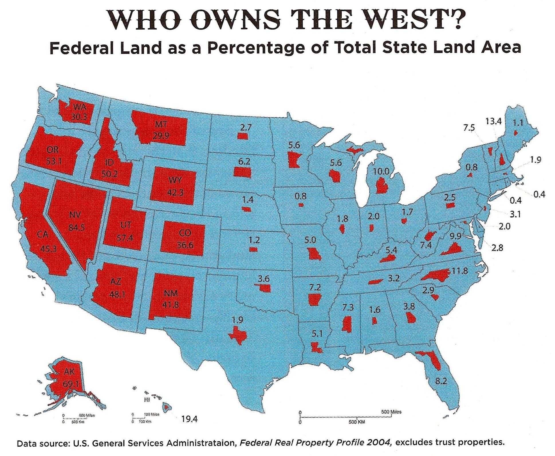
MondayMap: The Feds Own 84.5 Percent of Nevada

map-federal_lands

The Unites States government owns almost one-third (28 percent) of the entire nation. Through various agencies that include the United States Forest Service, the National Park Service, the Bureau of Land Management, and the Fish and Wildlife Service, the total owned “by the people, for the people” comes to a staggering 640 million acres of land.

Perhaps not surprisingly, most of the federal owned land lies in the Rocky Mountains and to the West. In fact, the US government owns 47 percent of the land in the western states, versus just 4 percent in states east of the Rockies.

More from Frank Jacobs over at Strange Maps:

The rough beauty of the American West seems as far as you can get from the polished corridors of power in Washington DC. Until you look at the title to the land. The federal government owns large tracts of the western states: from a low of 29.9% in Montana, already more than the national average, up to a whopping 84.5% in Nevada.

What is all that federal land for? And exactly who is in charge? According to the Congressional Research Service [4], a total area of just under 610 million acres – more than twice the size of Namibia – is administered by no more than 4 federal government agencies:

* The United States Forest Service (USFS), which oversees timber harvesting, recreation, wildlife habitat protection and other sustainable uses on a total of 193 million acres – almost the size of Turkey – mainly designated as National Forests.

* The National Park Service (NPS) conserves lands and resources on 80 million acres – a Norway-sized area – in order to preserve them for the public. Any harvesting or resource removal is generally prohibited.

* the Bureau of Land Management (BLM), managing 248 million acres [5] – an area the size of Egypt – has a multiple-use, sustained-yield mandate, supporting energy development, recreation, grazing, conservation, and other uses.

* the Fish and Wildlife Service (FWS) manages 89 million acres – an area slightly bigger than Germany – to conserve and protect animal and plant species.

Check out the entire story here.

Image: Federal Real Property Profile. Courtesy: U.S. General Services Administration /  ‘Can the West Lead Us To A Better Place?‘ an article in Stanford Magazine.

MondayMap: Food Rhythms

rhythm-of-food-screenshot

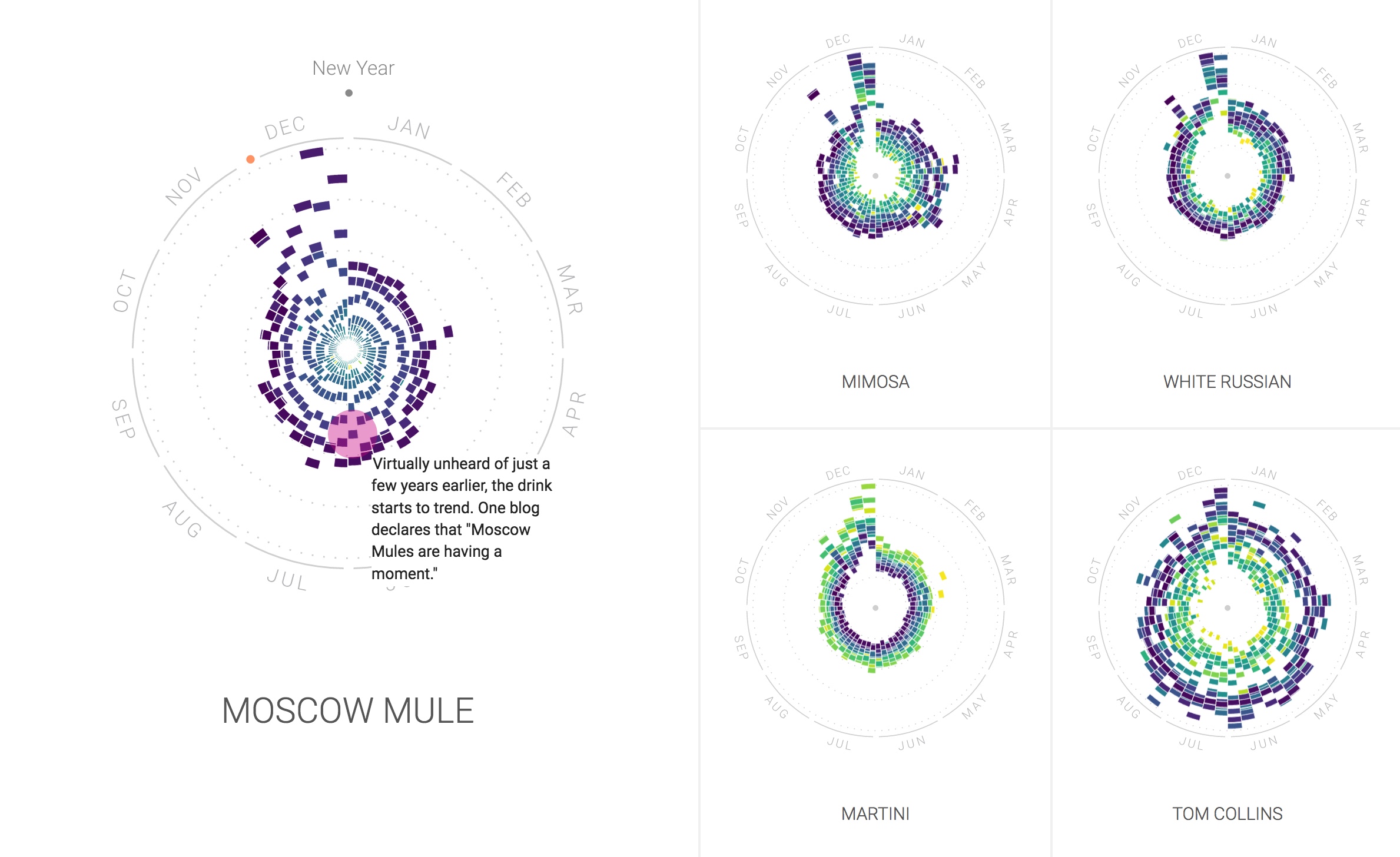
OK, I admit it. Today’s article is not strictly about a map, but I couldn’t resist these fascinating data visualizations. The graphic show some of the patterns and trends that can be derived from the vast mountains of data gathered from Google searches. A group of designers and data scientists from Truth & Beauty teamed up with Google News Labs to produce a portfolio of charts that show food and drink related searches over the last 12 years.

The visual above shows a clear spike in cocktail related searches in December (for entertaining during holiday season). Interestingly Searches for a “Tom Collins” have increased since 2004 whereas those for “Martini” have decreased in number. A more recent phenomenon on the cocktail scene seems to be the “Moscow Mule”.

Since most of the searches emanated in the United States the resulting charts show some fascinating changes in the nation’s collective nutritional mood. While some visualizations confirm the obvious — fruit searches peak when in season; pizza is popular year round — some  specific insights are more curious:

  • Orange Jell-O [“jelly” for my British readers] is popular for US Thanksgiving.
  • Tamale searches peak around Christmas.
  • Pumpkin spice latte searches increase in the fall, but searches are peaking earlier each year.
  • Superfood searches are up; fat-free searches are down.
  • Nacho searches peak around Super Bowl Sunday.
  • Cauliflower may be the new Kale.

You can check out much more from this gorgeous data visualization project at The Rhythm of Food.

Image: Screenshot from Rhythm of Food. Courtesy: Rhythm of Food.

MondayMap: National Superlatives

international-number-ones-2016

OK, I must admit that some maps can be somewhat dubious. Or, is it all maps?

Despite their shaky foundations some maps form the basis for many centuries of human (mis-)understanding, only to be subsequently overturned by a new (and improved) chart. For instance, the geocentric models of our cosmos courtesy of Aristotle and Ptolemy were not replaced for around 1,400 years, until Nicolaus Copernicus proposed a heliocentric view of the solar system.

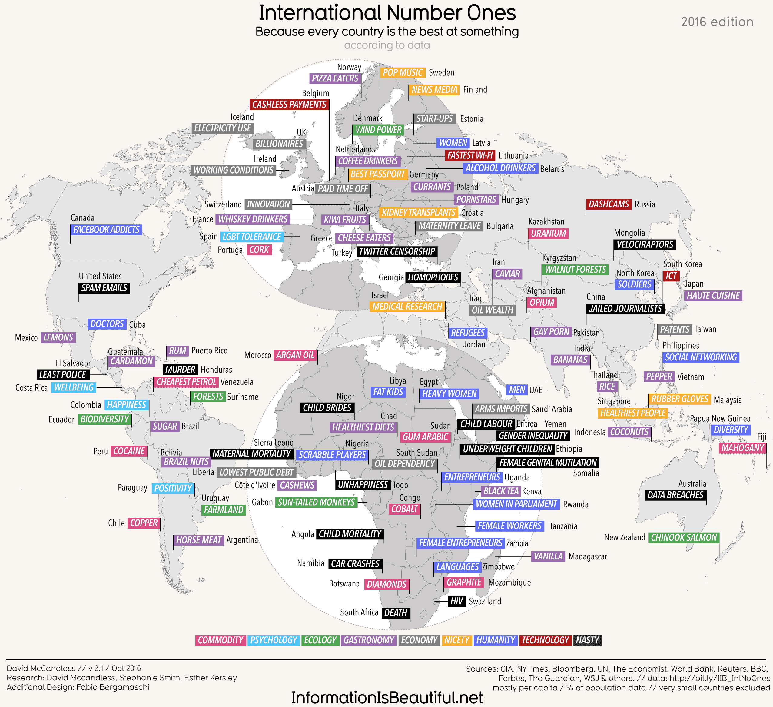
Thus, keep in mind the latest view of our globe, courtesy of David McCandless. He compiled this esoteric worldview, because every nation is the best at something, from a collection of global data sources.

Looks like the US is “best” at spam (not the luncheon meat). While Russia leads in, of course, dash cams.

MondayMap: The Architecture of Music

musicmap

A couple of years ago I wrote about Every Noise At Once a visualization, with samples, of (almost) every musical genre. At last count Glenn McDonald’s brainchild had algorithmically-generated and scatter-plotted 1,496 genres.

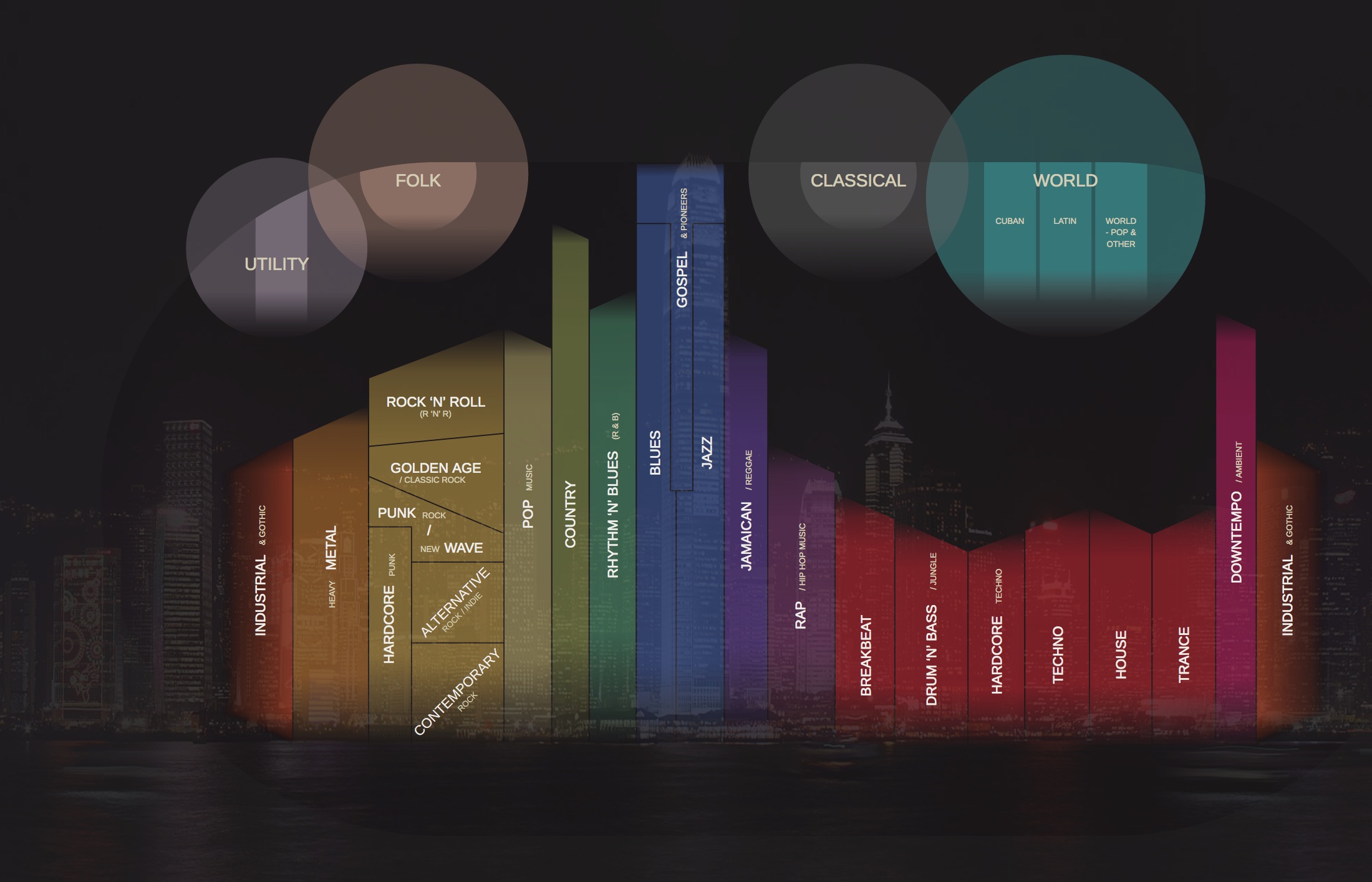
Now courtesy of Belgian architect Kwinten Crauwels we have the next gorgeous visual iteration of the music universe — Musicmap. It took Crauwels seven years to construct this astounding and comprehensive, interactive map of music genres, sub-genres and their relationships. It traces the genealogy of around 150 years of popular music.

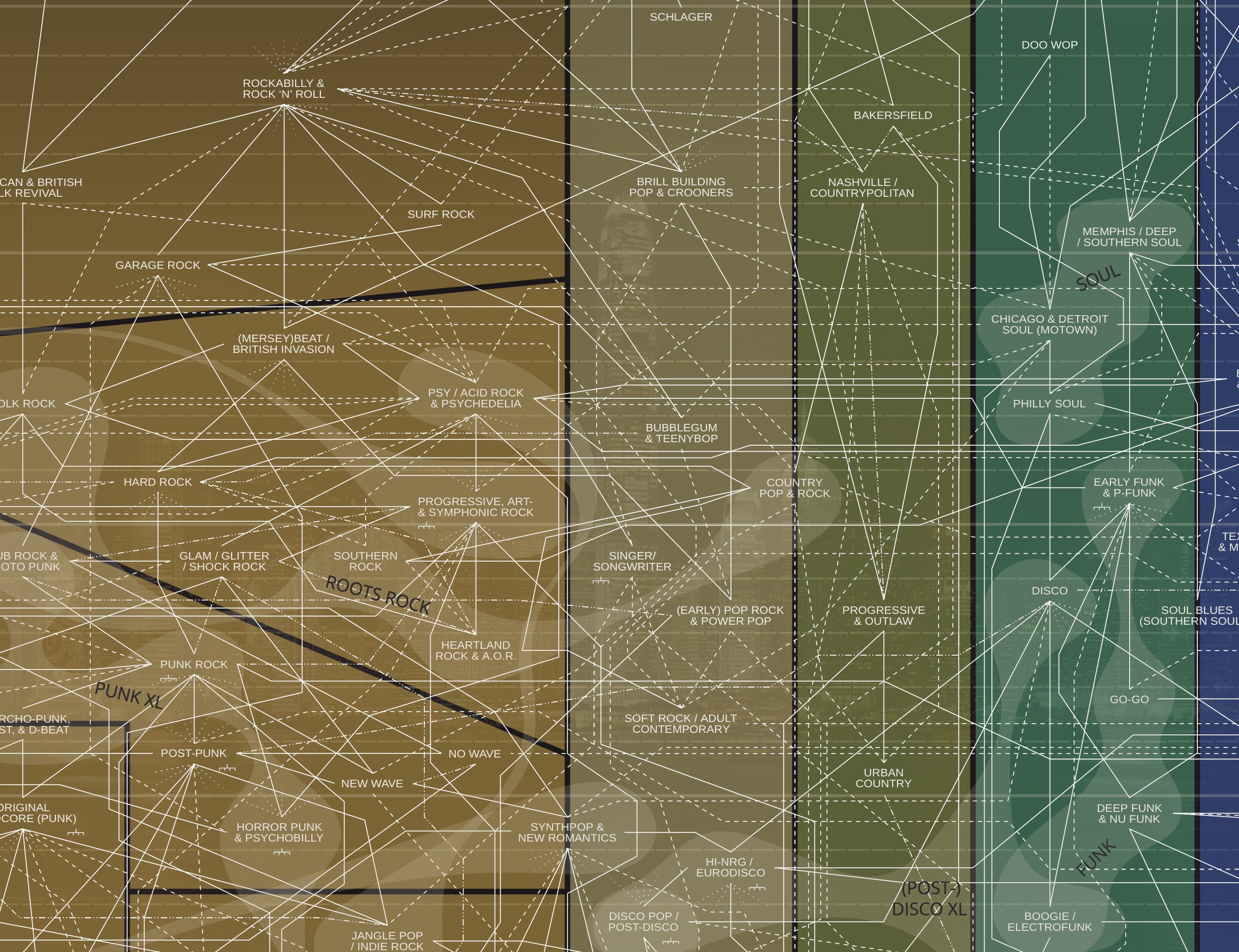
Crauwels color-coded each of the major genres and devised different types of lines to show different relationships across the hundreds of genres and sub-genres. You can fly around the map to follow the links and drill-down to learn more about each musical style.

musicmap2

Now you can visually trace how Garage Rock is related to Detroit’s Motown and Doo Wop, or how present day Industrial Synth evolved from Krautrock of the 1970s.

It’s a visual, and musical, masterpiece. Read more about Musicmap here.

Image: Musicmap screenshots. Courtesy of Kwinten Crauwels, Musicmap.

MondayMap: Red Versus Blue

1883-county-map

You may believe that colorful, graphical electoral analysis is a relatively recent phenomenon. You know, those cool red and blue maps (and now sometimes green or purple) of each state and country.

But our present day news networks and the internet did not invent this type of infographic map.

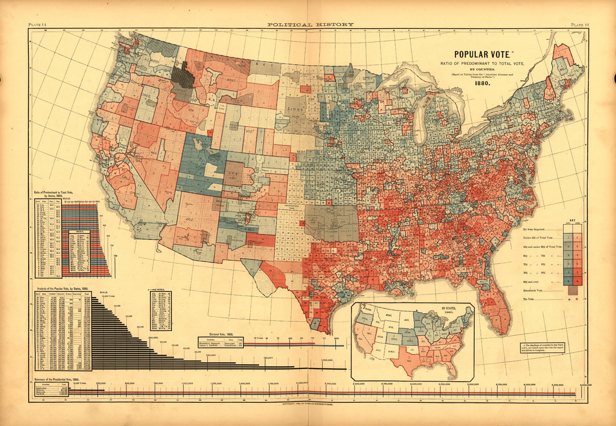
Susan Schulten, chair of the history department at the University of Denver, discovered what may be the earliest example of a US county-level electoral map. Published in 1883 it shows results from the 1880 Presidential election between Republican James Garfield and Democrat Winfield Hancock. Garfield won.

Two notable reversals in the 1880 map versus today’s counterpart: First, Democrats are in red; Republicans in blue. Second, Democrats make up the majority in much of the South and Midwest; Republicans rule in the Northeast. Interestingly, the color scheme switched numerous times over the last hundred years and did not formally become Democrat=Blue, Republican=Red until the 2000 election cycle.

For more fascinating details of our electoral maps, past and present, check out this article by Lazaro Gamio, over at the Washington Post.

Image: Plate 11 from Scribner’s Statistical Atlas of the United States, published in 1883. Courtesy: Library of Congress. Public Domain.

MondayMap: Yes. A Magnetic, Foldable Dymaxion Map

dymaxion_map_ocean2

fuller_projection

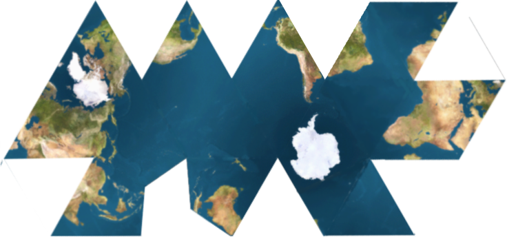
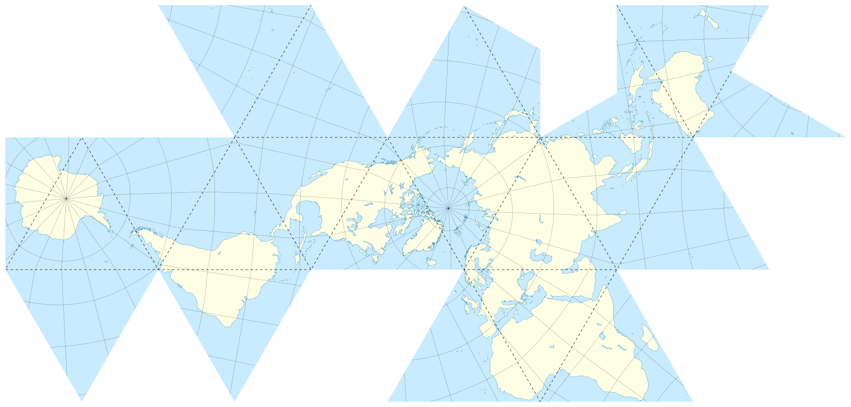
For a map geek [or are we nerds?] like me a foldable Dymaxion map with a 2D and 3D projection is rather cool. Buckminster Fuller and architect, collaborator Shoji Sadao created this peculiar view of our world over 60 years ago, 1954 to be more precise.

A key advantage of this map was that it was held to be the least distorted of all 2D projections of our 3D globe, and it could also be accurate in three dimensions.

For example, Fuller correctly maintained that his projection has less distortion of relative size of areas compared to the common Mercator projection. It also has less distortion of shapes of areas when compared to the Gall–Peters projection.

Now we can enjoy a magnetic globe version of Fuller and Sadao’s creation courtesy of designer Brendan Ravenhill.

From Wired:

Brendan Ravenhill reimagines the Dymaxion Map as a magnetic globe. Like Fuller’s original map, Ravenhill’s globe can exist in two or three dimensions. Laid flat, it’s a series of 20 triangles that show Fuller’s projection as a single landmass. The back of each triangle features a magnet so you can fold the map into an angular globe. “Really it’s a toy, but a toy that has a lot of resonance and importance,” Ravenhill says.

Fuller made his map endlessly reconfigurable. And while Ravenhill’s design nods to that idea with its partitioned triangles, there’s really only one way to put the puzzle together correctly. “You know you’re doing it wrong if there’s a magnet where Antarctica is supposed to be,” he says.

Read the entire article here.

Images: 1) An icosahedral net showing connected oceans surrounding Antarctica; 2) Unfolded Dymaxion map with nearly contiguous land masses. Courtesy: Wikipedia. CC BY 2.5.

MondayMap: European Stereotypes

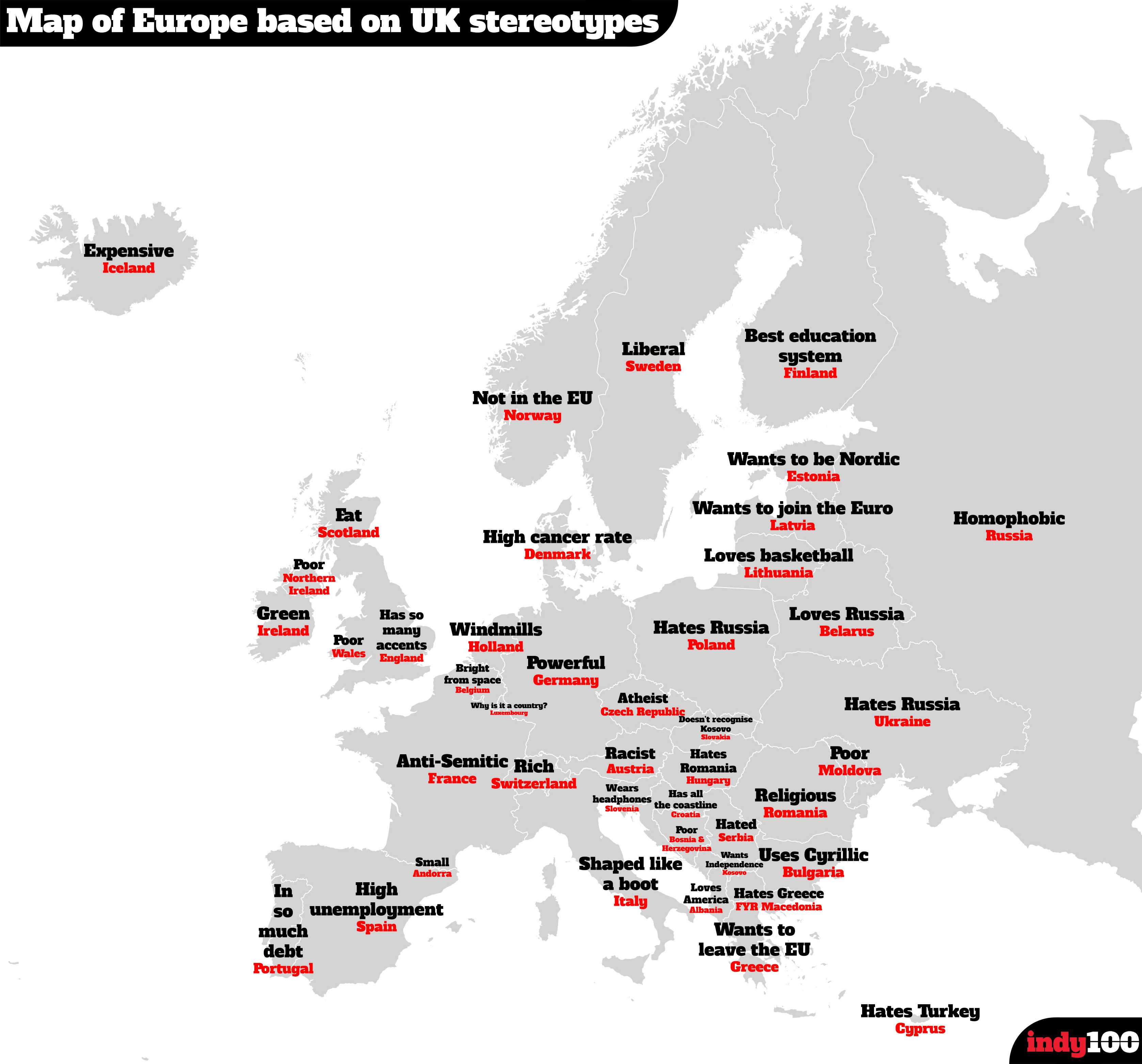
map-europe-google-stereotypeHot on the heels of the map of US state stereotypes I am delighted to present a second one. This time it’s a map of Google searches in the UK for various nations across Europe. It was compiled by taking the most frequent result from Google’s autocomplete function. For instance, type in, “Why is Italy…”, and Google automatically fills in the most popular result with “Why is Italy shaped like a boot”.

Highlighting just a few: Switzerland is viewed as rich; Austria is racist; Ireland is green.

Map: European nation stereotypes by British Google users. Courtesy: Independent Media.

MondayMap: State Stereotypes

map-uk-google-stereotype

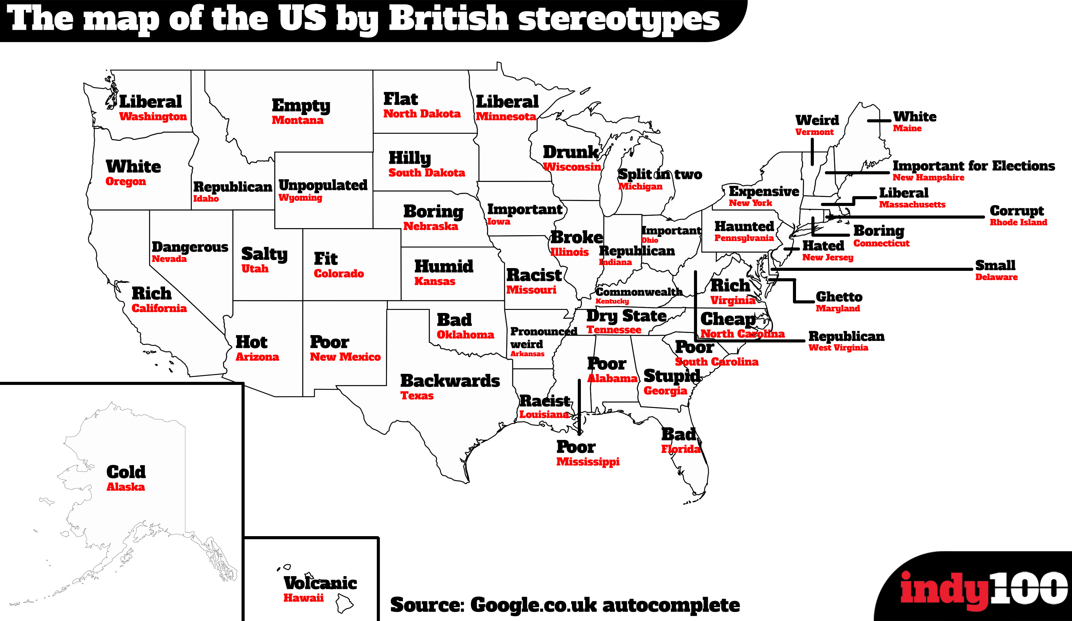
An interesting map courtesy of Google searches in the UK shows some fascinating stereotypes for each of the US fifty states. It was compiled by taking the most frequent result from Google’s autocomplete function. For instance, type in, “Why is Colorado so…”, and Google automatically fills in the most popular result with “Why is Colorado so fit”.

It’s not entirely scientific but interesting nonetheless. Highlighting just a few: Wisconsin is viewed as drunk; Louisiana as racist; Colorado as fit; and, Nevada as dangerous.

Map: US state stereotypes by British Google users. Courtesy: Independent Media.

MondayMap: Addresses Made Simple

what3words-buckingham-palace

I recently tripped over a fascinating mapping app called What3Words. Its goal is to make location and address finding easier. It does so in quite a creative way — by assigning a unique combination of 3 words to every 3×3 square meter location on the planet. In What3Words own words:

So in case you were wondering. The Queen’s official residence in London (Buckingham Palace) is fence.gross.bats.

It’s far more accurate than a postal address and it’s much easier to remember, use and share than a set of coordinates.

Better addressing improves customer experience, delivers business efficiencies, drives growth and helps the social & economic development of countries.

How cool.

Image: What3Words screenshot. Courtesy: What3Words.

MondayMap: Beyond the Horizon

Map-beach-view

Andy Woodruff is a cartographer, he makes maps. His most recent construction is a series of whimsical maps that visualize what many off us at least once in our lives may have pondered.

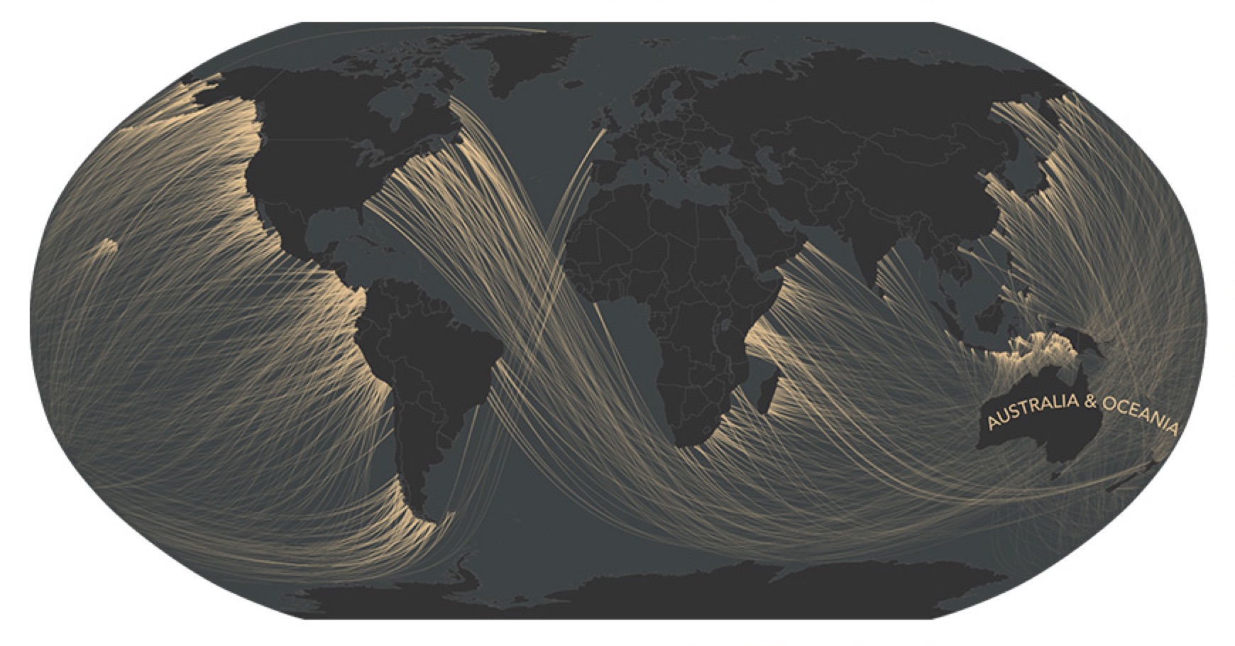
When we are at the beach looking out to sea, casting our eyes to the distant horizon, we often wonder what lies beyond. If you could set off and walk in a straight line from your small plot of sand (or rock) across the vast ocean where would you first make landfall? Andy Woodruff’s “Beyond the Sea” maps answer this question, and the results are surprising.

For instance, if you happen to be looking out from any beach on the US Eastern Seaboard — and your vision could bend and stretch over the horizon — you would see the Southern coastline of Australia. So, drop the boring atlas and Google Maps and go follow some more of Andy Woodruff’s fascinating great circles.

From NPR:

Ever stood on the coastline, gazing out over the horizon, and wondered what’s on the other side? Pondered where you’d end up if you could fly straight ahead until you hit land?

Turns out the answer might be surprising. And even if you pulled out an atlas — or, more realistically, your smartphone — you might have trouble figuring it out. Lines of latitude won’t help, and drawing a path on most maps will lead you astray.

Cartographer Andy Woodruff, who recently embarked on a project called Beyond the Sea to illustrate this puzzle, says there are two simple reasons why it’s harder than it seems to figure out which coast lies directly on the other side of the horizon.

First, coastlines are “wacky,” he writes on his blog. And second, well, the Earth is round.

The crookedness of the world’s coastlines means moving a few miles up or down the coast will leave you facing a different direction (assuming your gaze is straight out, perpendicular to the coast around you).

Read the entire story here.

Map: Beach view of Australia. Courtesy Andy Woodruff.


MondayMap: Connectography

21st-century-silk-road

I have had a peculiar affinity for luscious atlases and maps since childhood. They held promises of future explorations and adventures over ancient peaks, within new cultures, beyond borders. I also have a strange fascination for data, patterns in data, trends, probabilities, statistics (though I’m no mathematician).

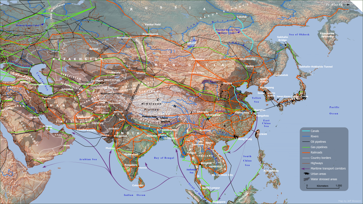
So when I see someone combining maps and data, especially in fundamentally new ways, I have to take notice. Enter stage left: Parag Khanna. He’s a global strategist, author and a true cartophile. His new book “Connectography: Mapping the Future of Global Civilization,” uses grand cartographic visualizations to show how the world is steadily integrating.

Even for a reasonably geo-savvy person like me it’s eye-opening to see maps being used in insightful new ways — especially to draw attention to our global neighborhood and its common challenges.

One striking example shows the ties of railways, cables, pipelines and trade that further bind nations rather than the borders, often arbitrarily drawn, that once divided.

Dive into are recent interview with Parag Khanna here.

Map: The emerging silk roads of commerce interlinking 60 Asian nations. Courtesy: Parag Khanna, “Connectography: Mapping the Future of Global Civilization”.

MondayMap: A is Blue; B is Red

MPK1-426_Sykes_Picot_Agreement_Map_signed_8_May_1916

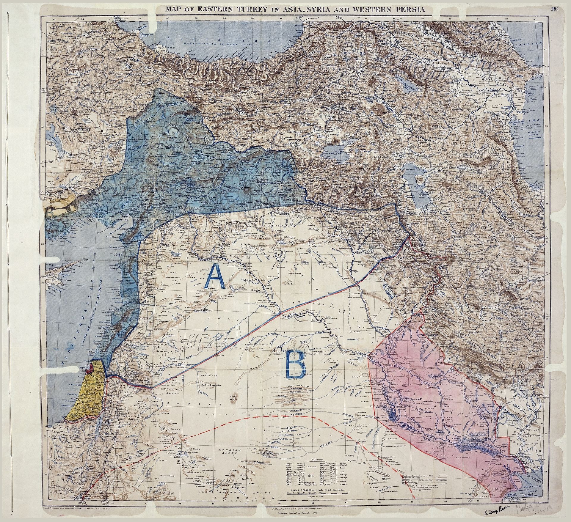
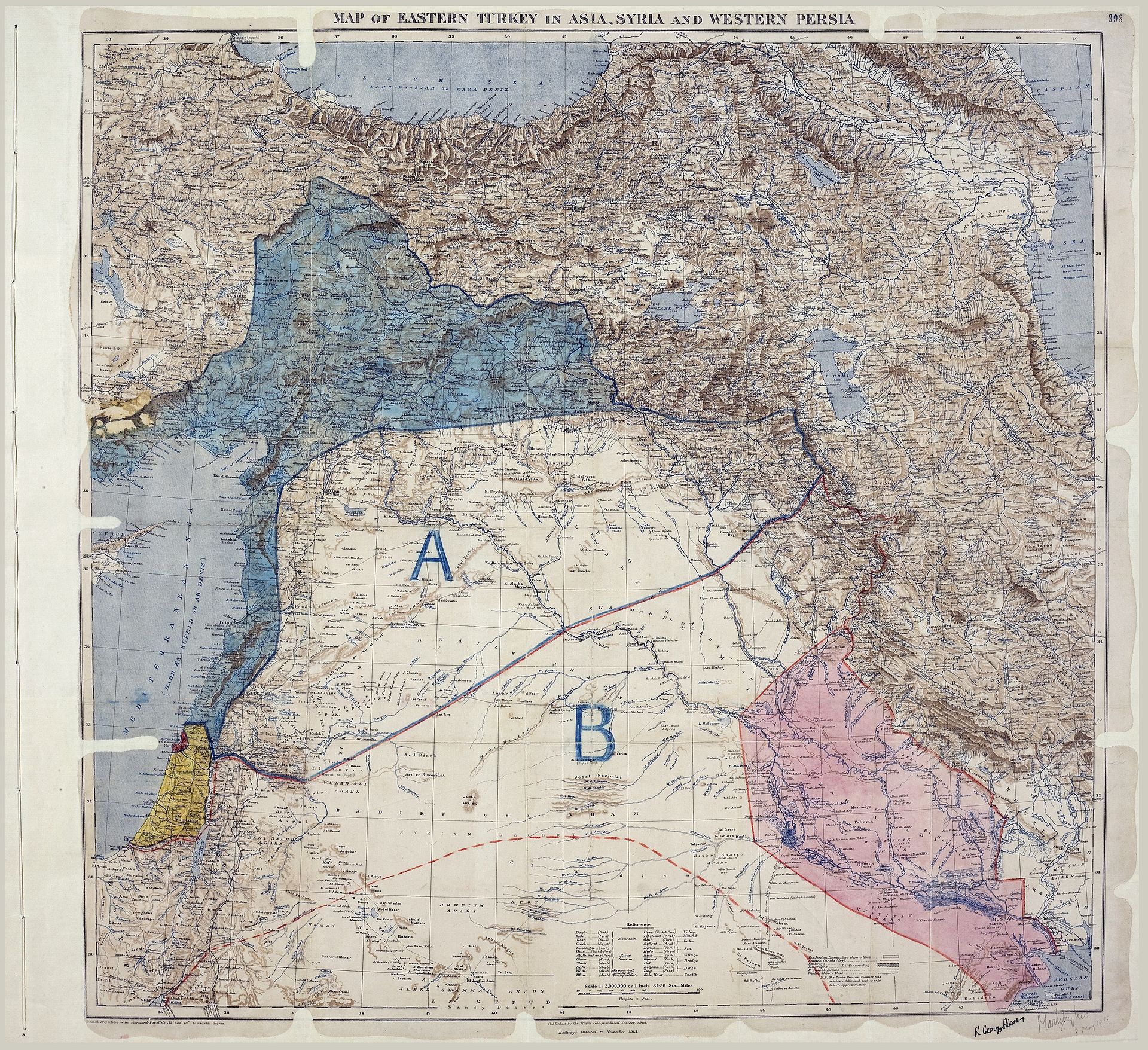
A hundred years ago the first two letters of the alphabet and a somewhat arbitrary line drawn on a map changed the Earth’s geopolitical axis. The ramifications continue to be felt across the globe to this day.

The waning days of WWI finally precipitated the decline of the once vast Ottoman Empire. During this period the eventual victors, the Allied Powers of Great Britain, France, and Russia, began secretly planning how they would carve up the spoils, which covered much of the Middle East. With Russia then succumbing to its own revolution, Britain and France were free to delineate their own “spheres of influence”, allocating huge areas of territory (and peoples) to themselves and their appointed heirs. “A” was to be blue and would belong to France; the region covered what is now Syria, Lebanon, northern Iraq and parts of Turkey. “B” was to be red and would be administered by the British; it covered modern-day Jordan, southern Iraq and parts of what is now Israel.

The agreement and the new map were negotiated in 1915-16 by the British and French diplomats Mark Sykes and François Georges-Picot, respectively. It was signed on May 16, 1916, and became known as the Sykes-Picot Agreement. The secret deal reneged on numerous promises and assurances made to leaders in the region, and subsequently disenfranchised entire populations for generations.

Read more about the map, the secret deal and the hundred years of turbulent and bloody consequence in David Fromkin’s book, A Peace to End All Peace: The Fall of the Ottoman Empire and the Creation of the Modern Middle East (1989).

Map: Sykes–Picot Agreement showing Eastern Turkey in Asia, Syria and Western Persia, and areas of control and influence agreed between the British and the French. Courtesy: Royal Geographical Society, 1910-15. Signed by Mark Sykes and François Georges-Picot, 16 May 1916.

MondayMap: Thought Police

Map-Freedom-of-ThoughtThe inflammatory rhetoric of the US election gives me pause. Pretenders to the nation’s highest office include xenophobes and racists. Yet their words of fear and hate are protected by one of the simplest and most powerful sentences written in to law:

Congress shall make no law respecting an establishment of religion, or prohibiting the free exercise thereof; or abridging the freedom of speech, or of the press; or the right of the people peaceably to assemble, and to petition the Government for a redress of grievances.

We should give thanks for these words every day. The words protect our utterances, thoughts, beliefs and associations.

Citizens in many other country’s are not so lucky. Some nations give preferential treatment to believers in the state-sanctioned religion and discriminate against those who don’t adhere. Other nations will severely persecute or punish their own people for blasphemy and/or apostasy.

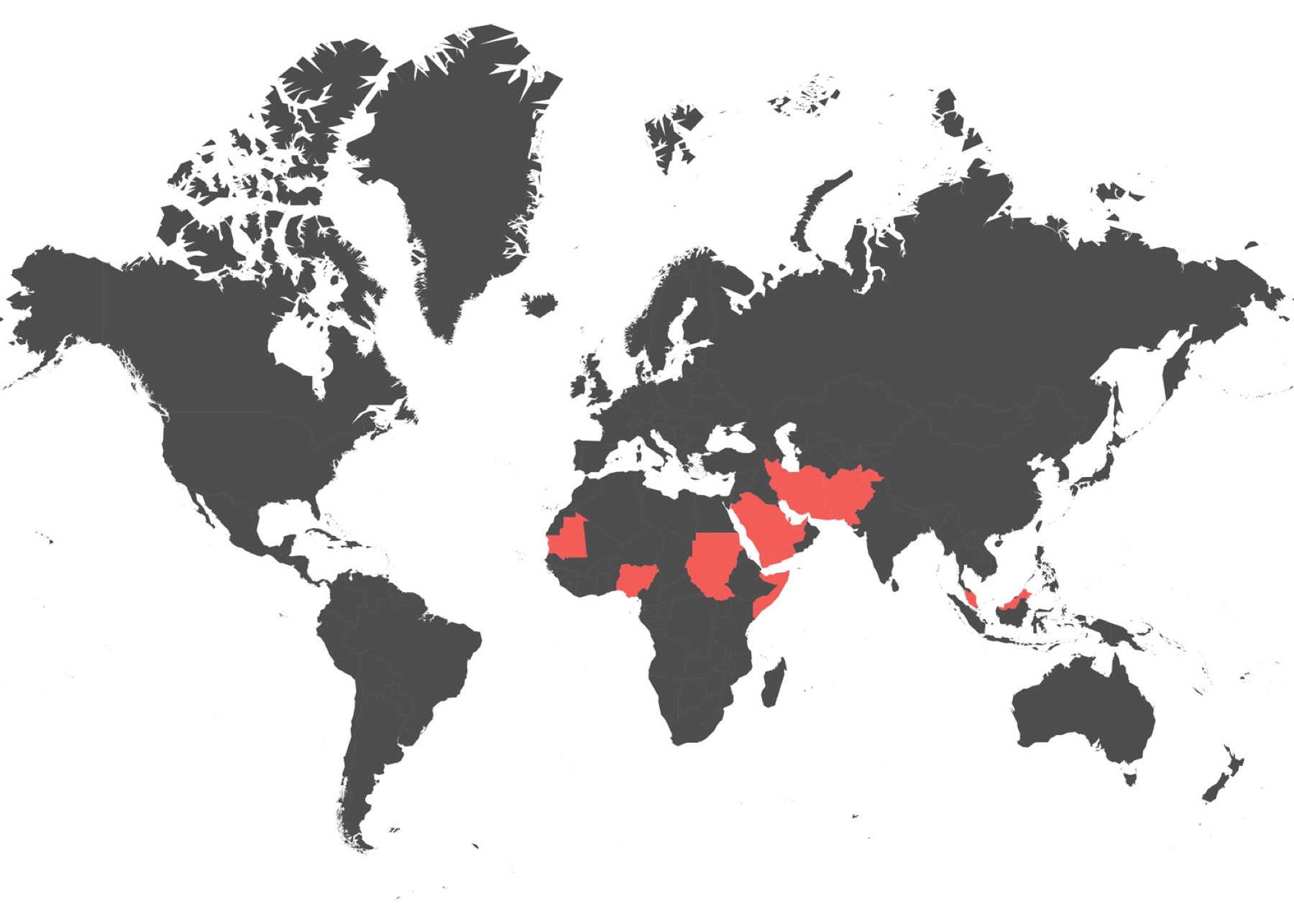
Then there’s the list of 13, including: Somalia, Sudan, Mauritania, Nigeria, Afghanistan, Iran, Maldives, Pakistan, Iraq, Qatar, Saudi Arabia, United Arab Emirates, Yemen. Here you can be put to death for not believing or for criticizing or renouncing your state-imposed belief system.

Please visit the International Humanist and Ethical Union to read the full Freedom of Thought Report 2015. It makes for sobering reading — hard to believe we all live in the 21st century.

Image: Countries (in red) where apostasy is punishable by death. Courtesy of Independent / International Humanist and Ethical Union.

MondayMap: Internet Racism

map-internet-racism

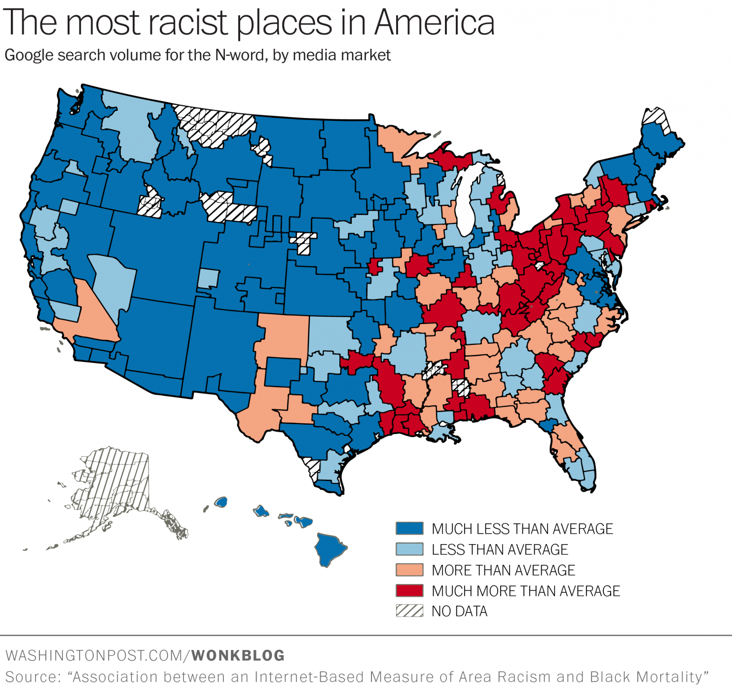
Darkest blue and light blue respectively indicate much less and less racist areas than the national average. The darkest red indicates the most racist zones.

No surprise: the areas with the highest number of racists are in the South and the rural Northeastern United States. Head west of Texas and you’ll find fewer and fewer pockets of racists. Further, and perhaps not surprisingly, the greater the degree of n-word usage the higher is the rate of black mortality.

Sadly, this map is not of 18th or 19th century America, it’s from a recent study, April 2015, posted on Public Library of Science (PLOS) ONE.

Now keep in mind that the map highlights racism through tracking of pejorative search terms such as the n-word, and doesn’t count actual people, and it’s a geographic generalization. Nonetheless it’s a stark reminder that we seem to be two nations divided by the mighty Mississippi River and we still have a very long way to go before we are all “westerners”.

From Washington Post:

Where do America’s most racist people live? “The rural Northeast and South,” suggests a new study just published in PLOS ONE.

The paper introduces a novel but makes-tons-of-sense-when-you-think-about-it method for measuring the incidence of racist attitudes: Google search data. The methodology comes from data scientist Seth Stephens-Davidowitz. He’s used it before to measure the effect of racist attitudes on Barack Obama’s electoral prospects.

“Google data, evidence suggests, are unlikely to suffer from major social censoring,” Stephens-Davidowitz wrote in a previous paper. “Google searchers are online and likely alone, both of which make it easier to express socially taboo thoughts. Individuals, indeed, note that they are unusually forthcoming with Google.” He also notes that the Google measure correlates strongly with other standard measures social science researchers have used to study racist attitudes.

This is important, because racism is a notoriously tricky thing to measure. Traditional survey methods don’t really work — if you flat-out ask someone if they’re racist, they will simply tell you no. That’s partly because most racism in society today operates at the subconscious level, or gets vented anonymously online.

For the PLOS ONE paper, researchers looked at searches containing the N-word. People search frequently for it, roughly as often as searches for  “migraine(s),” “economist,” “sweater,” “Daily Show,” and “Lakers.” (The authors attempted to control for variants of the N-word not necessarily intended as pejoratives, excluding the “a” version of the word that analysis revealed was often used “in different contexts compared to searches of the term ending in ‘-er’.”)

Read the entire article here.

Image: Association between an Internet-Based Measure of Area Racism and Black Mortality. Courtesy of Washington Post / PLOS (Public Library of Science) ONE.

MondayMap: House Prices via London Tube

London-Tube-house-prices

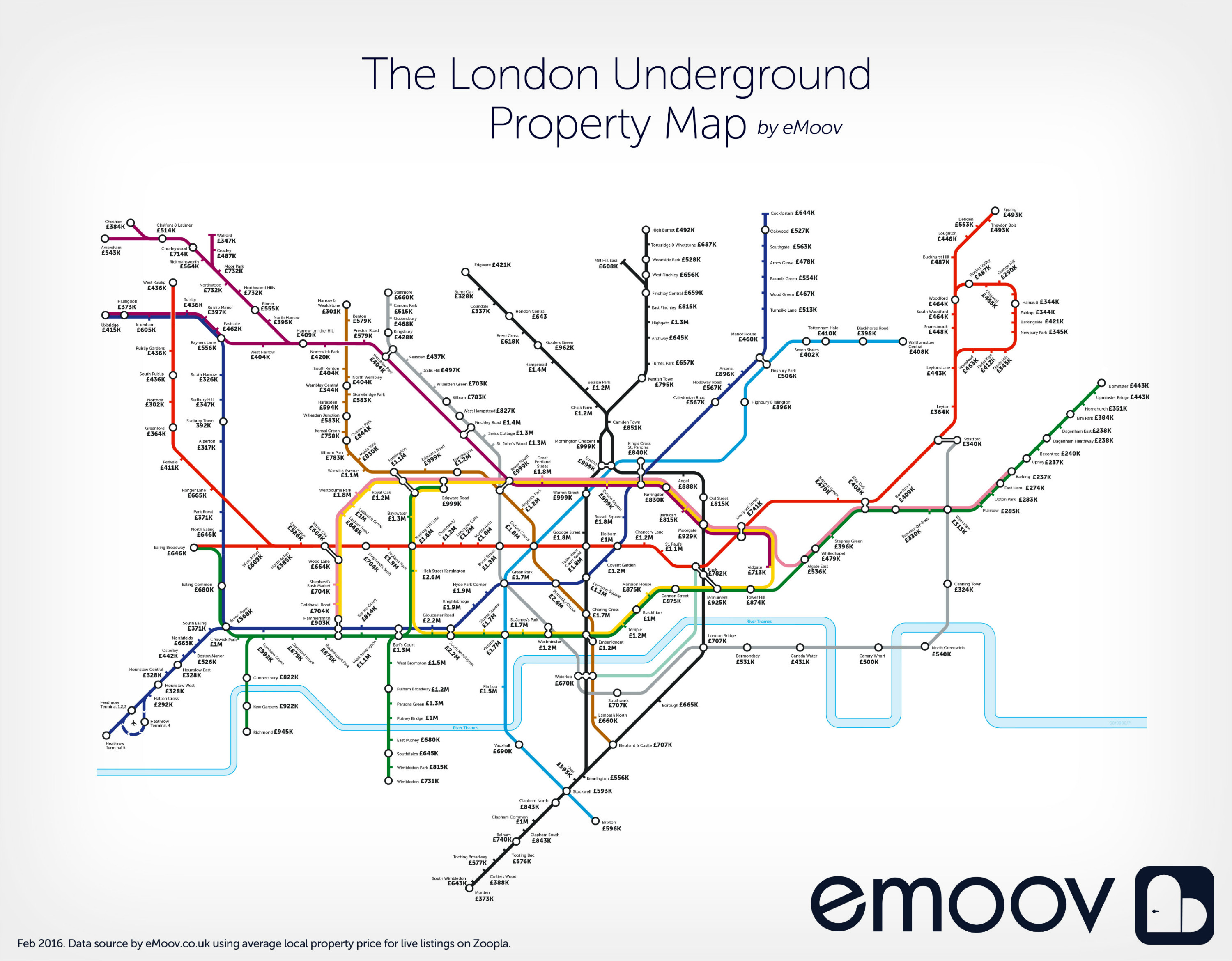
While I no longer live in London, I grew up there and still have a special affection for the city. I’m even attached to its famed Tube map (subway for my US readers). So I found this rendition rather fascinating — a map of average house prices at and around each tube station. No surprise: house prices on and inside the Central Line (red) are the highest, with the lowest hovering around £500,000 (roughly $710,000). Read more about this map here.

Map courtesy of eMoov with data provided by Zoopla.


MondayMap: 80 Years After Prohibition

Alcohol_control_in_United_States

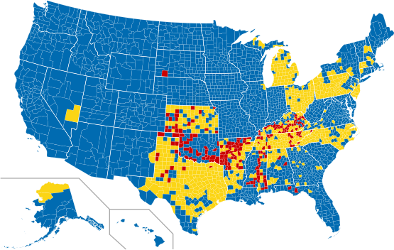
Apparently, Prohibition (of alcohol sales, production and transportation) ended in the United States in 1933. But, you’d be surprised to learn that more than 80 years later many regions across the nation still have restrictions and bans.

The map shows areas where alcohol is restricted: red indicates that the sales of alcohol is banned (dry); blue shows that it is allowed (wet); and yellow denotes that the county is “partially dry” or “moist”.

Interestingly, Kansas, Tennessee and Mississippi are dry states by default and require individual counties to opt in to sell alcohol. Texas is a confusing patchwork: of Texas’s 254 counties, 11 are completely dry, 194 are partially dry, and 49 are entirely wet. And, to to add to the confusion, Texas prohibits off-premises sale of liquor — but not beer and wine — all day on Sunday and select holidays.

Read more here.

Image: Map shows dry (red), wet (blue), and mixed (yellow) counties in the United States as of March 2012. Courtesy of Wikipedia.

MondayMap: National Business Emotional Intelligence

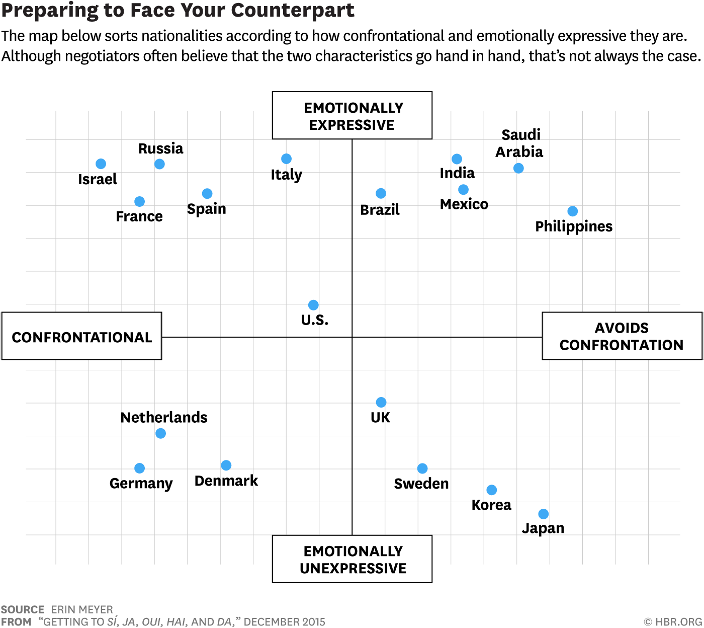
A recent article in the Harvard Business Review (HBR) gives would-be business negotiators some general tips on how best to deal with counterparts from other regions of the world. After all, getting to yes and reaching a mutually beneficial agreement across all parties does require a good degree of cultural sensitivity and emotional intelligence.

map-Emotional-Counterpart

While there is no substitute to understanding other nations through travel and cultural immersion, the HBR article describes some interesting nuances to help those lacking in geographic awareness, international business experience,  and cross-cultural wisdom. The first step in this exotic journey is rather appropriately, a map.

No surprise, the Japanese and Filipinos shirk business confrontation, whereas the Russians and French savor it. Northern Europeans are less emotional, while Southern Europeans and Latin Americans are much more emotionally expressive.

From Frank Jacobs over at Strange Maps:

Negotiating with Filipinos? Be warm and personal, but stay polite. Cutting das Deal with Germans? Stay cool as ice, and be tough as nails. So what happens if you’re a German doing business in the Philippines?

That’s not the question this map was designed to answer. This map — actually, a diagram — shows differences in attitudes to business negotiations in a number of countries. Familiarise yourself with them, then burn the drawing. From now on, you’ll be a master international dealmaker.

Vertically, the map distinguishes between countries where it is highly haram to show emotions during business proceedings (Japan being the prime example) and countries where emotions are an accepted part of il commercio (yes, Italians are emotional extroverts — also in business).

The horizontal axis differentiates countries with a very confrontational negotiating style — think heated arguments and slammed doors — from places where decorum is the alpha and omega of commercial dealings. For an extreme example of the former, try trading with an Israeli company. For the latter, I refer you to those personable but (apparently also) persnickety Filipinos.

Read the entire article here.

Map courtesy of Erin Meyer, professor and the program director for Managing Global Virtual Teams at INSEAD. Courtesy of HBR / Strange Maps.

MondayMap: Search by State

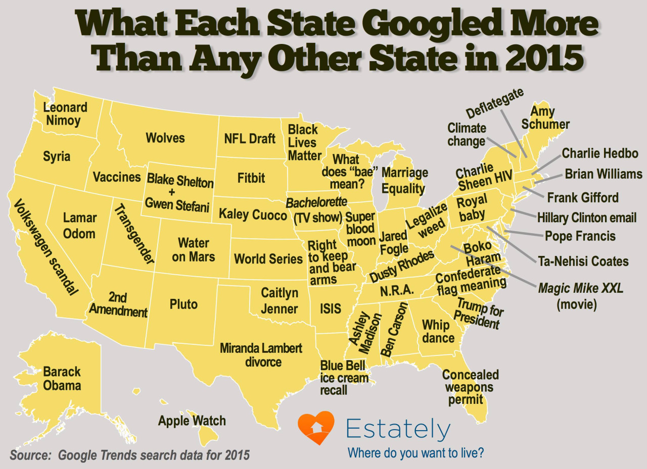
This treasure of a map shows the most popular Google search terms by state in 2015.

Google-search-by-state-2015

The vastly different searches show how the United States really is a collection of very diverse and loosely federated communities. The US may be a great melting pot, but down at the state level its residents seem to care about very different things.

For instance, while Floridians favorite search was “concealed weapons permit“, residents of Mississippi went rather dubiously for “Ashley Madison“, and Oklahoma’s top search was “Caitlyn Jenner“. Kudos to my home state, residents there put aside politics, reality TV, guns and other inanities by searching most for “water on mars“. Similarly, citizens of New Mexico looked far beyond their borders by searching most for “Pluto“.

And, I have to scratch my head over why New York State cares more about “Charlie Sheen HIV” and Kentucky prefers “Dusty Rhodes” over Washington State’s search for “Leonard Nimoy”.

The map was put together by the kind people at Estately. You can read more fascinating state-by-state search rankings here.

MondayMap: Our Beautiful Blue Home

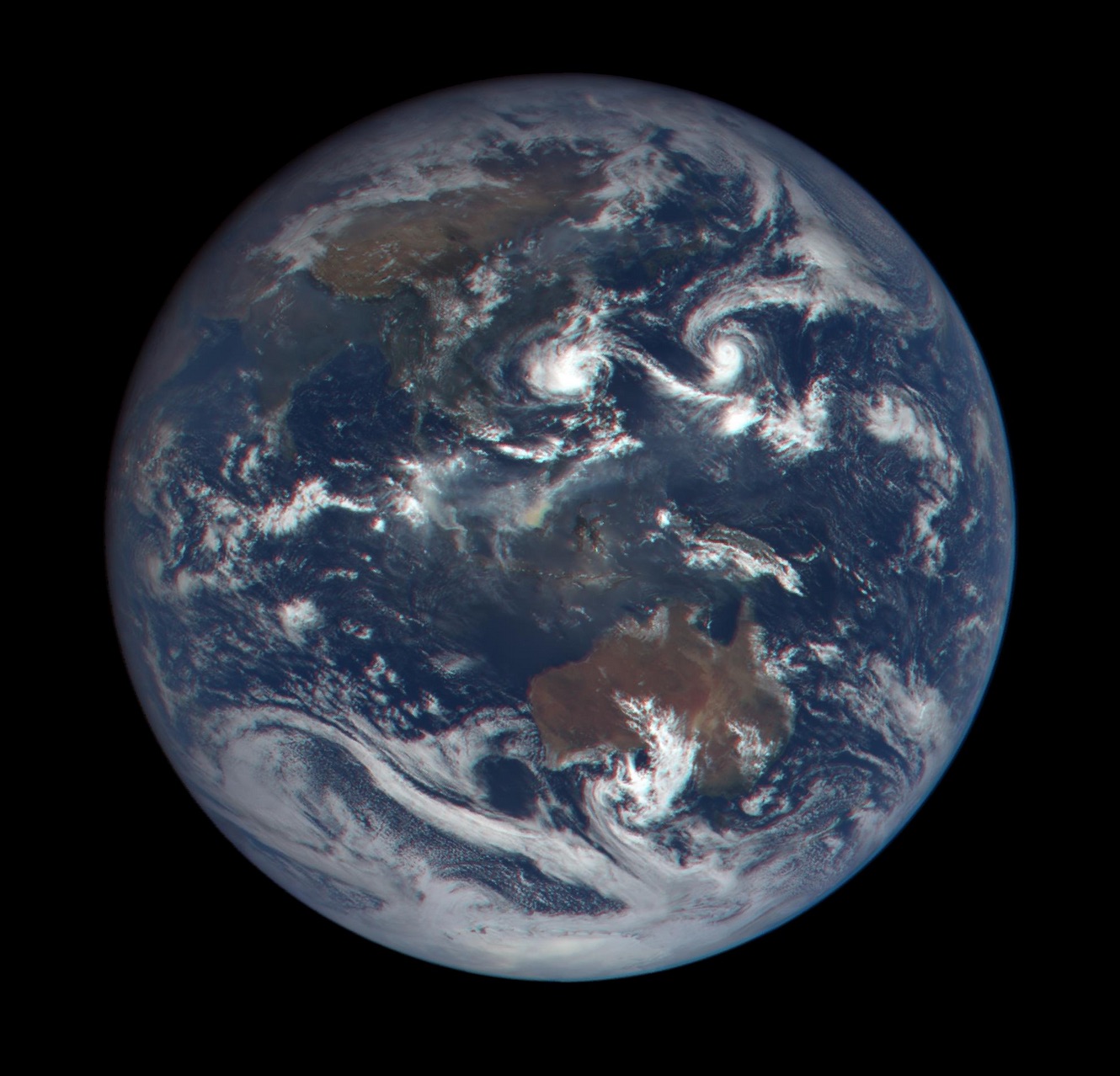
OK, OK, I cheated a little this week. I don’t have a map story.

But I couldn’t resist posting the geographic-related news of NASA’s new website. Each day, the agency will post a handful of images of our gorgeous home, as seen from the DSCOVR spacecraft. DSCOVR is parked at the L-1 Lagrangian Point, about 1 million miles from Earth and 92 million from the Sun, where the gravitational forces of the three bodies balance. It’s a wonderful vantage point to peer at our beautiful blue planet.

DSCOVR-Earth-image-19Oct2015

You can check out NASA’s new website here.

Image: Earth as imaged from DSCOVR on October 19, 2015. Courtesy of NASA, NOAA and the U.S Air Force.

MondayMap: The Grocery Store Project

grocery-store-project-screenshot

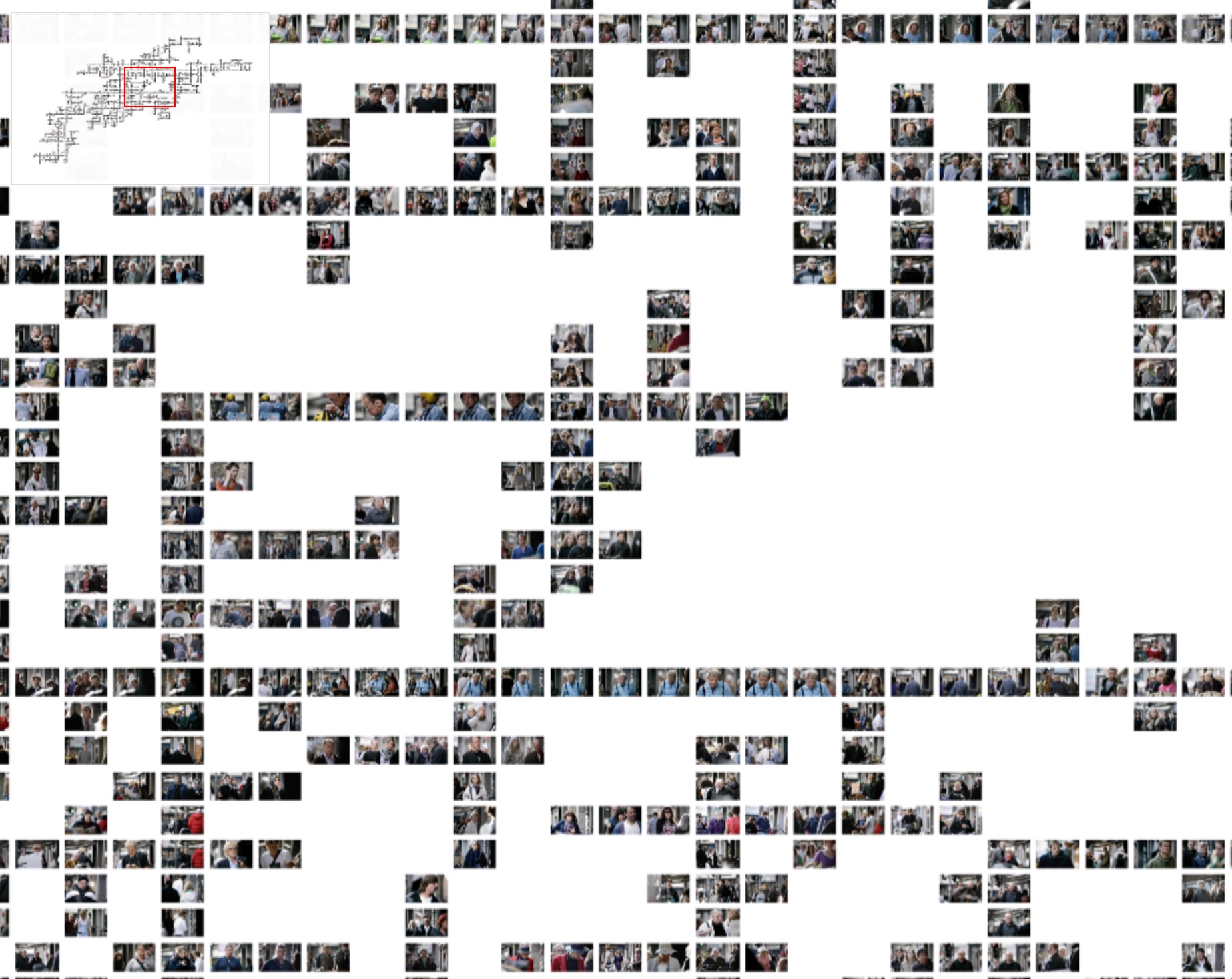
Danish photographer Simon Høgsberg spent 21 months shooting 97,000 images of people outside one Copenhagen supermarket. Høgsberg began taking pictures in April 2010 outside a supermarket called Føtex — fascinated by the varied sea of humanity that passed him by each day.

Then he cataloged the images and plotted the intersections of people who featured in multiple photographs on different days. The result is a visual map of the lives of around 450 people who randomly cropped up multiple times during his obsessive photo-shoot. Høgsberg titled his work The Grocery Store Project. I’m still grappling with the value of this huge undertaking, but it is wholly fascinating nonetheless.

Image: Screenshot of The Grocery Store Project. Courtesy of Simon Høgsberg.

MondayMap: Cuisine Cartography

map-US-state-food

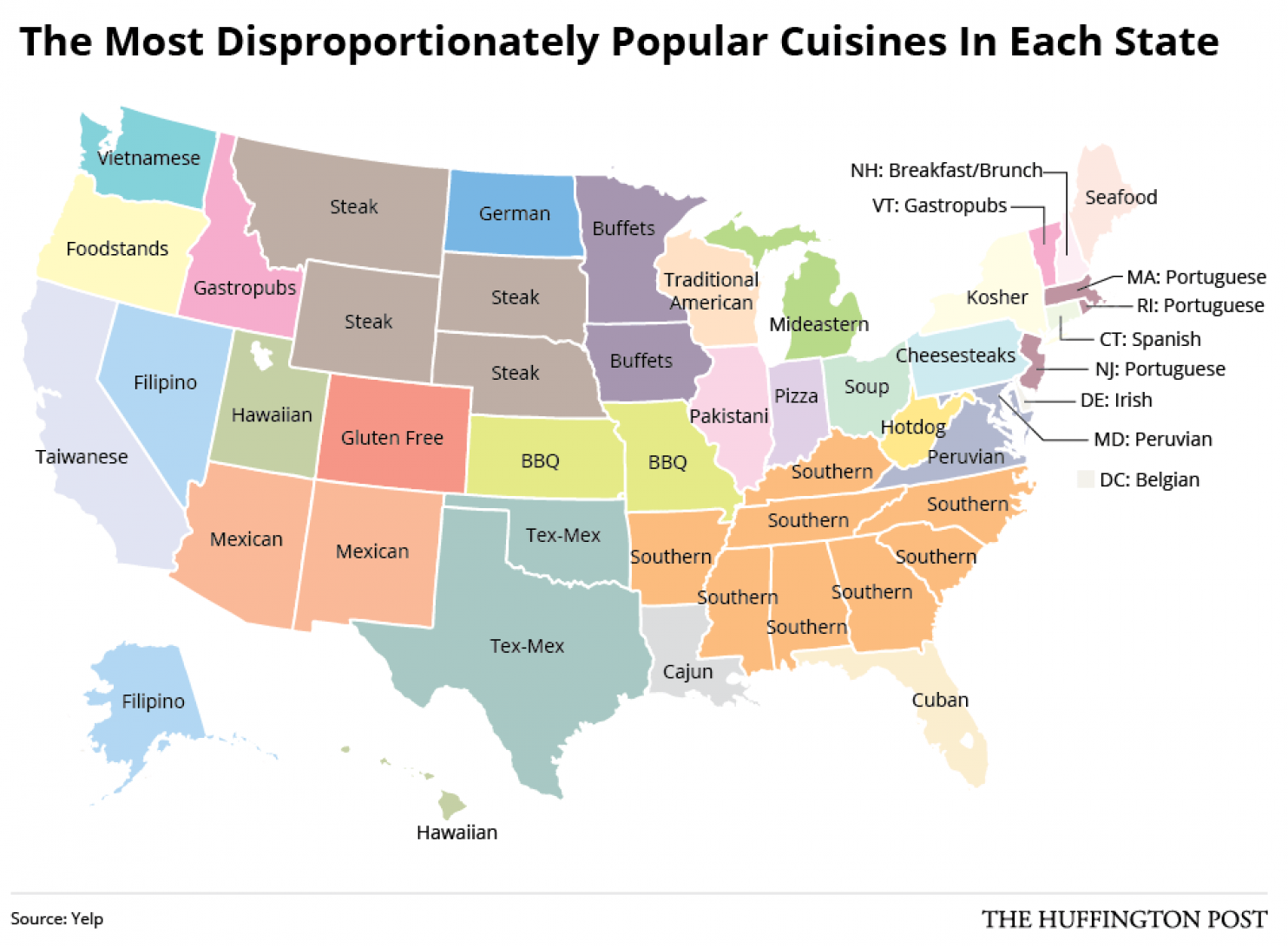
Love food? Love maps? You’re in the right place. What could be better than a story that combines both. To peripheral watchers of America and those who believe fast food is America’s national treasure, it may come as a surprise to see that many US states show very different tastes in cuisine, and some quite exotic.

The map shows cuisines that are the most common in each state barring the national average, which is probably pizza. Asian food mostly dominates the west coast, but Oregon does it’s own thing, of course (food stands). Coloradans maintain their health and fitness bent by favoring gluten-free foods, while Texans still love their tex-mex. There are some fascinating surprises: peruvian food tops the list in Virginia and Maryland; Vermont and Idaho prefer gastropubs; and West Virginia craves hot dogs.

Read more here.

Map courtesy of Huffington Post / Yelp.

MondayMap: Grey or Gray Matter?

infographic-spelling_bee_chart

The dumbing down of the United States continues apace. While 9-15 year-olds participating in this year’s national spelling bee competition seem to have no problem with words like “syzygy”, “onomatopoeia” and “triskaidekaphobia”, the general adult population is in dire linguistic straits.

An analysis of online search queries by Vocativ and Google Trends highlights some rather disturbing misspellings of rather common words. Though, what makes the survey so fascinating is to see the variations mapped by state. Sadly, around a dozen states had the most trouble with the word “grey”, including California, Illinois, Kansas, Michigan and North Dakota. Arkansas, on the other hand, should be proud (or not), that its residents have the most trouble with the word “diarrhea” (US spelling), while residents of Idaho can’t seem to spell “antelope”.  Texans get hung up on “beautiful” and those living in Wyoming can’t seem to spell “jelous” [sic].

Read more from Vocativ here.

Infographic courtesy of Vocativ / Google Trends.


MondayMap: The State of Death

distinctive-causes-of-death-by-state

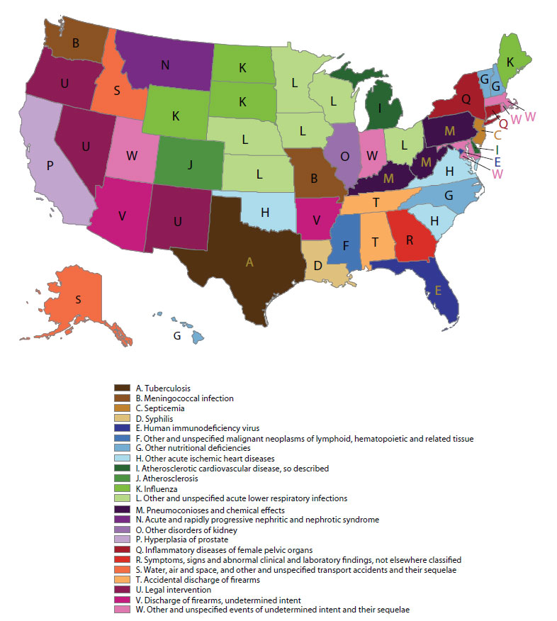
It’s a Monday, so why not dwell on an appropriately morbid topic — death. Or, to be more precise, a really cool map that shows the most distinctive causes of death for each state. We know that across the United States in general the most common causes of death are heart disease and cancer. However, looking a little deeper shows other, secondary causes that vary by state. So, leaving aside the top two, you will see that a resident of Tennessee is more likely to die from “accidental discharge of firearms”, while someone from Alabama will succumb to syphilis. Interestingly, Texans are more likely to depart this mortal coil from tuberculosis; Georgians from “abnormal clinical problems not elsewhere classified”. While Alaskans — no surprise here — lead the way in deaths from airplane, boating and “unspecified transport accidents”.

Read more here.

Map: Distinctive cause of death by state. Courtesy of Francis Boscoe, New York State Cancer Registry.


MondayMap: Imagining a Post-Post-Ottoman World

Sykes_Picot_Agreement_Map_signed_8_May_1916

The United States is often portrayed as the world’s bully and nefarious geo-political schemer — a nation responsible for many of the world’s current political ills. However, it is the French and British who should be called to account for much of the globe’s ongoing turmoil, particularly in the Middle East. After the end of WWI the victors expeditiously carved up the spoils of the vanquished Austro-Hungarian and Ottoman Empires. Much of Eastern Europe and the Middle East was divvied and traded just a kids might swap baseball or football (soccer) cards today. Then President of France Georges Clemenceau and British Prime Minister David Lloyd George famously bartered and gifted — amongst themselves and their friends — entire regions and cities without thought to historical precedence, geographic and ethnic boundaries, or even the basic needs of entire populations. Their decisions were merely lines to be drawn and re-drawn on a map.

So, it would be a fascinating — though rather naive — exercise to re-draw many of today’s arbitrary and contrived boundaries, and to revert regions to their more appropriate owners. Of course, where and when should this thought experiment begin and end? Pre-roman empire, post-normans, before the Prussians, prior to the Austro-Hungarian Empire, or after the Ottomans, post-Soviets, or after Tito, or way before the Huns, Vandals and the Barbarians and any number of the Germanic tribes?

Nevertheless, essayist Yaroslav Trofimov takes a stab at re-districting to pre-Ottoman boundaries and imagines a world with less bloodshed. A worthy dream.

From WSJ:

Shortly after the end of World War I, the French and British prime ministers took a break from the hard business of redrawing the map of Europe to discuss the easier matter of where frontiers would run in the newly conquered Middle East.

Two years earlier, in 1916, the two allies had agreed on their respective zones of influence in a secret pact—known as the Sykes-Picot agreement—for divvying up the region. But now the Ottoman Empire lay defeated, and the United Kingdom, having done most of the fighting against the Turks, felt that it had earned a juicier reward.

“Tell me what you want,” France’s Georges Clemenceau said to Britain’s David Lloyd George as they strolled in the French embassy in London.

“I want Mosul,” the British prime minister replied.

“You shall have it. Anything else?” Clemenceau asked.

In a few seconds, it was done. The huge Ottoman imperial province of Mosul, home to Sunni Arabs and Kurds and to plentiful oil, ended up as part of the newly created country of Iraq, not the newly created country of Syria.

The Ottomans ran a multilingual, multireligious empire, ruled by a sultan who also bore the title of caliph—commander of all the world’s Muslims. Having joined the losing side in the Great War, however, the Ottomans saw their empire summarily dismantled by European statesmen who knew little about the region’s people, geography and customs.

The resulting Middle Eastern states were often artificial creations, sometimes with implausibly straight lines for borders. They have kept going since then, by and large, remaining within their colonial-era frontiers despite repeated attempts at pan-Arab unification.

The built-in imbalances in some of these newly carved-out states—particularly Syria and Iraq—spawned brutal dictatorships that succeeded for decades in suppressing restive majorities and perpetuating the rule of minority groups.

But now it may all be coming to an end. Syria and Iraq have effectively ceased to function as states. Large parts of both countries lie beyond central government control, and the very meaning of Syrian and Iraqi nationhood has been hollowed out by the dominance of sectarian and ethnic identities.

The rise of Islamic State is the direct result of this meltdown. The Sunni extremist group’s leader, Abu Bakr al-Baghdadi, has proclaimed himself the new caliph and vowed to erase the shame of the “Sykes-Picot conspiracy.” After his men surged from their stronghold in Syria last summer and captured Mosul, now one of Iraq’s largest cities, he promised to destroy the old borders. In that offensive, one of the first actions taken by ISIS (as his group is also known) was to blow up the customs checkpoints between Syria and Iraq.

“What we are witnessing is the demise of the post-Ottoman order, the demise of the legitimate states,” says Francis Ricciardone, a former U.S. ambassador to Turkey and Egypt who is now at the Atlantic Council, a Washington think tank. “ISIS is a piece of that, and it is filling in a vacuum of the collapse of that order.”

In the mayhem now engulfing the Middle East, it is mostly the countries created a century ago by European colonialists that are coming apart. In the region’s more “natural” nations, a much stronger sense of shared history and tradition has, so far, prevented a similar implosion.

“Much of the conflict in the Middle East is the result of insecurity of contrived states,” says Husain Haqqani, an author and a former Pakistani ambassador to the U.S. “Contrived states need state ideologies to make up for lack of history and often flex muscles against their own people or against neighbors to consolidate their identity.”

In Egypt, with its millennial history and strong sense of identity, almost nobody questioned the country’s basic “Egyptian-ness” throughout the upheaval that has followed President Hosni Mubarak’s ouster in a 2011 revolution. As a result, most of Egypt’s institutions have survived the turbulence relatively intact, and violence has stopped well short of outright civil war.

Turkey and Iran—both of them, in bygone eras, the center of vast empires—have also gone largely unscathed in recent years, even though both have large ethnic minorities of their own, including Arabs and Kurds.

The Middle East’s “contrived” countries weren’t necessarily doomed to failure, and some of them—notably Jordan—aren’t collapsing, at least not yet. The world, after all, is full of multiethnic and multiconfessional states that are successful and prosperous, from Switzerland to Singapore to the U.S., which remains a relative newcomer as a nation compared with, say, Iran.

Read the entire article here.

Image: Map of Sykes–Picot Agreement showing Eastern Turkey in Asia, Syria and Western Persia, and areas of control and influence agreed between the British and the French. Royal Geographical Society, 1910-15. Signed by Mark Sykes and François Georges-Picot, 8 May 1916. Courtesy of Wikipedia.
 

MondayMap: Bro or Dude Country?

Dude_Frequency

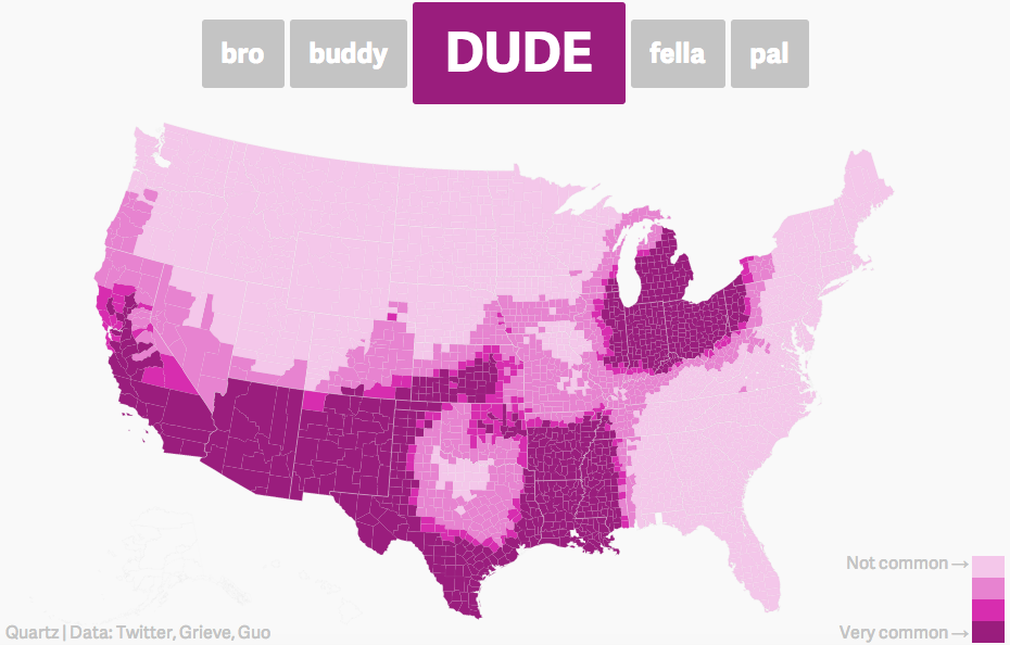
If you’re a male in Texas and have one or more BFFs, then chances are that you refer to each of them as “bro”. If you and your BFFs hang out in the deep south, then you’re more likely to call them “fella”. Fans of the Big Lebowski will be glad to hear the “dude” lives on — but mostly only in California, Southwestern US and around the Great Lakes.

See more maps of bros, fellas, dudes, and pals at Frank Jacobs blog here.

Image courtesy of Frank Jacobs / Jack Grieve and Diansheng Guo.

MondayMap: Music

everynoise

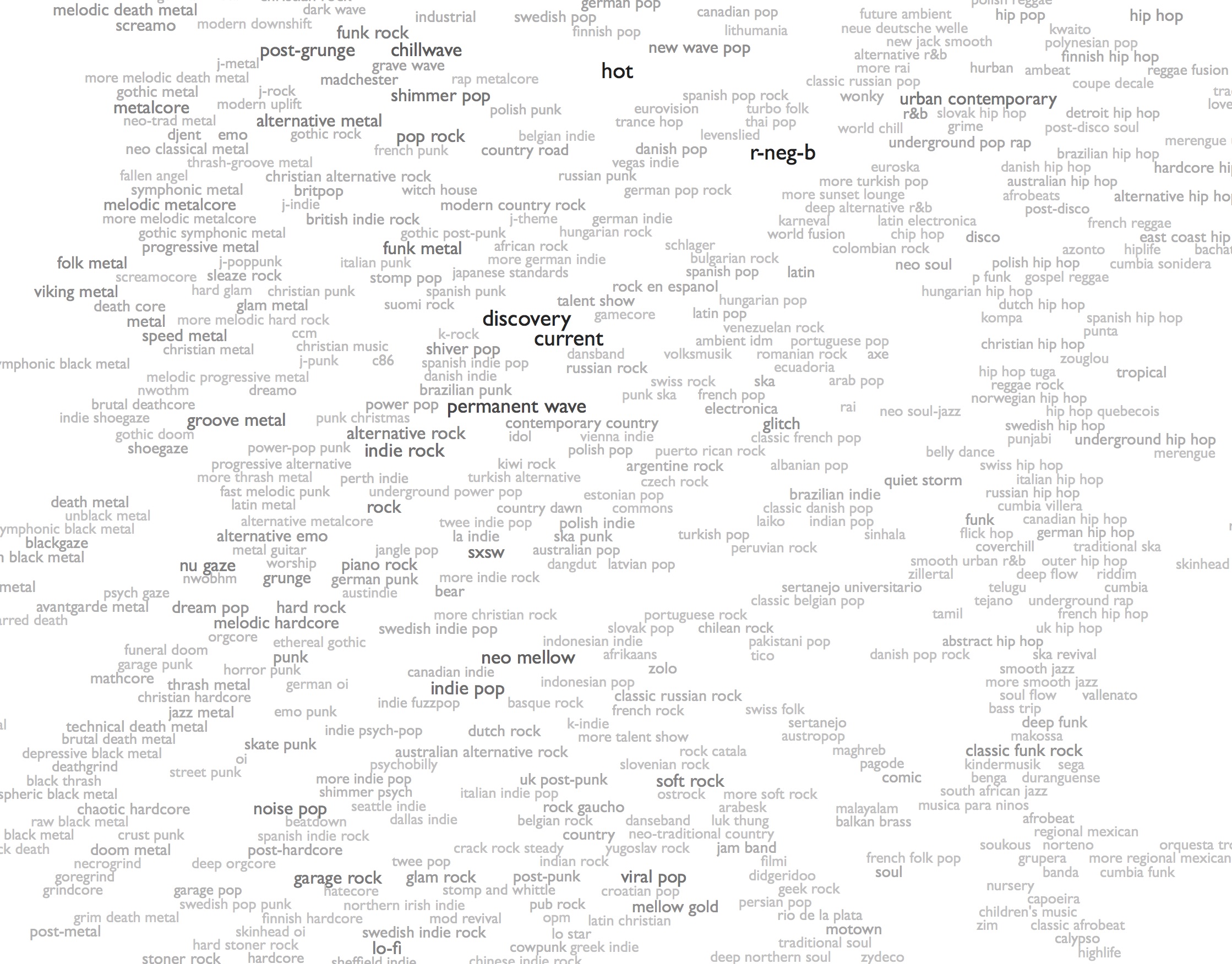
If you decide to do only one thing today, do this: visit everynoise, discover new music and have some expansive auditory fun.

Every Noise At Once is the brainchild of Glenn McDonald, a self-described data alchemist. He has sampled and categorized popular music into an astounding 1,264 genres — at current estimates.

You’re probably familiar with glam rock, emo punk, motown, ambient, garage, house, dub step, rap, metal and so on. But are you up on: neo-synthpop, fallen angel, deep orgcore, neurostep, death metal, skweee and cow punk? Well, here’s your chance to find out and expand your senses and your mind.

From the Guardian:

Music used to be easy. Some people liked rock. Some people liked pop. Some people liked jazz, blues or classical. And, basically, that was sort of it. However, musicians are a restless bunch and you can only play Smoke on the Water, Always Crashing in the Same Car or Roast Fish and Cornbread so many times before someone is bound to say: “Hang on a minute, what would happen if we played them all at the same time?” And so it is that new genres are born. Now imagine that happening for at least half a century or so – all over the world – and you reach a point at which, according to the engineer and “data alchemist” Glenn McDonald, there are now 1,264 genres of popular music; all you need to do is go directly to his startlingly cleverEveryNoise.com website and look – well, listen – for yourself.

Every Noise at Once is an ongoing attempt to build an algorithmically generated map of the entire musical genre-space, based on data tracked and analysed by Spotify’s music-intelligence division, The Echo Nest. It is also – in truth – one of the greatest time-eating devices ever created. You thought you had some kind of idea of just how much music is out there? You don’t. I don’t. But McDonald does. So he’s covered those genres – such as death metal, techno or hip-hop, which you’ll have heard of. Others, such as electro trash, indietronica or hard glam you may only have the most passing acquaintance with. Then, rather wonderfully, there are the outliers, those genres that you almost certainly didn’t even know existed – much less ever explored – suomi rock, shimmer psych,fourth world – right there at your fingertips any time you please. But the question is: what lives even further out than the outliers? How odd can it all get? Well, here are 10 genres (we could have nominated about 50) that even mouth-breathing indie record-shop blowhards (full disclosure: I used to be a mouth-breathing indie-record shop blowhard) would be hardpressed to help you find …

Read the entire story and sample some bands here.

Image: Every Noise at Once, screenshot. Courtesy of Glenn McDonald, Every Noise at Once.

MondayMap: Our New Address — Laniakea

laniakea_nrao

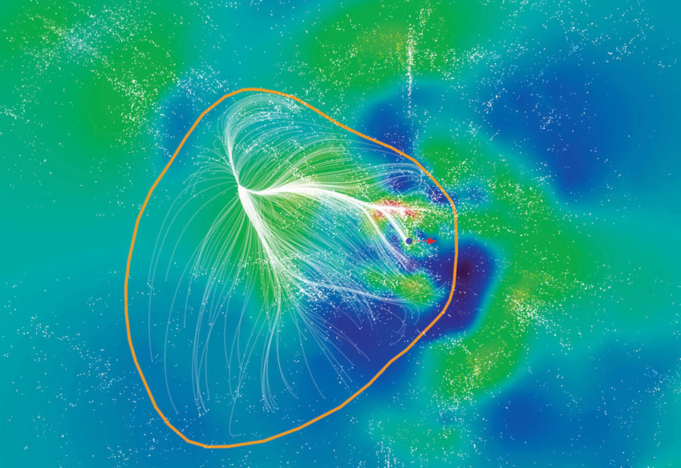
Once upon a time we humans sat smugly at the center of the universe. Now, many of us (though, not yet all) know better. Over the the last several centuries we learned and accepted that the Earth spun around the nearest Star, and not the converse. We then learned that the Sun formed part of an immense galaxy, the Milky Way, itself spinning in a vast cosmological dance. More recently, we learned that the Milky Way formed part of a larger cluster of galaxies, known as the Local Group.

Now we find that our Local Group is a mere speck within an immense supercluster containing around 100,000 galaxies spanning half a billion light years. Researchers have dubbed this galactic supercluster, rather aptly, Laniakea, Hawaiian for “immense heaven”. Laniakea is your new address. And, fascinatingly, Laniakea is moving towards an even larger grouping of galaxies named the Shapely supercluster.

From the Guardian:

In what amounts to a back-to-school gift for pupils with nerdier leanings, researchers have added a fresh line to the cosmic address of humanity. No longer will a standard home address followed by “the Earth, the solar system, the Milky Way, the universe” suffice for aficionados of the extended astronomical location system.

The extra line places the Milky Way in a vast network of neighbouring galaxies or “supercluster” that forms a spectacular web of stars and planets stretching across 520m light years of our local patch of universe. Named Laniakea, meaning “immeasurable heaven” in Hawaiian, the supercluster contains 100,000 large galaxies that together have the mass of 100 million billion suns.

Our home galaxy, the Milky Way, lies on the far outskirts of Laniakea near the border with another supercluster of galaxies named Perseus-Pisces. “When you look at it in three dimensions, is looks like a sphere that’s been badly beaten up and we are over near the edge, being pulled towards the centre,” said Brent Tully, an astronomer at the University of Hawaii in Honolulu.

Astronomers have long known that just as the solar system is part of the Milky Way, so the Milky Way belongs to a cosmic structure that is much larger still. But their attempts to define the larger structure had been thwarted because it was impossible to work out where one cluster of galaxies ended and another began.

Tully’s team gathered measurements on the positions and movement of more than 8,000 galaxies and, after discounting the expansion of the universe, worked out which were being pulled towards us and which were being pulled away. This allowed the scientists to define superclusters of galaxies that all moved in the same direction (if you’re reading this story on a mobile device, click here to watch a video explaining the research).

The work published in Nature gives astronomers their first look at the vast group of galaxies to which the Milky Way belongs. A narrow arch of galaxies connects Laniakea to the neighbouring Perseus-Pisces supercluster, while two other superclusters called Shapley and Coma lie on the far side of our own.

Tully said the research will help scientists understand why the Milky Way is hurtling through space at 600km a second towards the constellation of Centaurus. Part of the reason is the gravitational pull of other galaxies in our supercluster.

“But our whole supercluster is being pulled in the direction of this other supercluster, Shapley, though it remains to be seen if that’s all that’s going on,” said Tully.

Read the entire article here or the nerdier paper here.

Image: Laniakea: Our Home Supercluster of Galaxies. The blue dot represents the location of the Milky Way. Courtesy: R. Brent Tully (U. Hawaii) et al., SDvision, DP, CEA/Saclay.

MondayMap: Drought Mapping

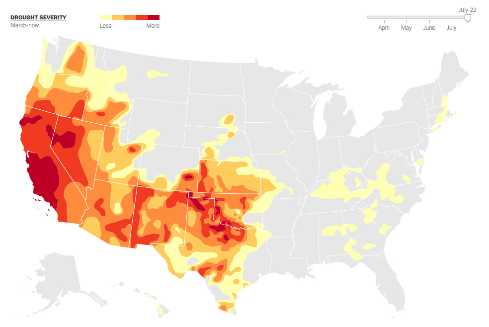
US-droughtThe NYT has an fascinating and detailed article bursting with charts and statistics that shows the pervasive grip of the drought in the United States. The desert Southwest and West continue to be parched and scorching. This is not a pretty picture for farmers and increasingly for those (sub-)urban dwellers who rely upon a fragile and dwindling water supply.

From the NYT:

Droughts appear to be intensifying over much of the West and Southwest as a result of global warming. Over the past decade, droughts in some regions have rivaled the epic dry spells of the 1930s and 1950s. About 34 percent of the contiguous United States was in at least a moderate drought as of July 22.
Things have been particularly bad in California, where state officials have approved drastic measures to reduce water consumption. California farmers, without water from reservoirs in the Central Valley, are left to choose which of their crops to water. Parts of Texas, Oklahoma and surrounding states are also suffering from drought conditions.
The relationship between the climate and droughts is complicated. Parts of the country are becoming wetter: East of the Mississippi, rainfall has been rising. But global warming also appears to be causing moisture to evaporate faster in places that were already dry. Researchers believe drought conditions in these places are likely to intensify in coming years.
There has been little relief for some places since the summer of 2012. At the recent peak this May, about 40 percent of the country was abnormally dry or in at least a moderate drought.

Read the entire story and see the statistics for yourself here.

Image courtesy of Drought Monitor / NYT.

MondayMap: Mississippi is Syria; Colorado is Slovenia

US-life-expectancy

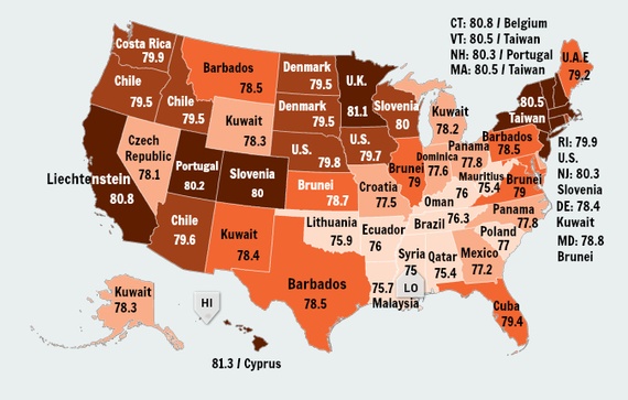
A fascinating map re-imagines life expectancy in the United States, courtesy of Olga Khazan over at measureofamerica.org. The premise of this map is a simple one: match the average life expectancy for each state of the union with that of a country having a similar rate. Voila. The lowest life expectancy rate belongs to Mississippi at 75 years, which equates with that of Syria. The highest, at 81.3 years, is found in Hawaii and Cyprus.

From the Atlantic:

American life expectancy has leapt up some 30 years in the past century, and we now live roughly 79.8 years on average. That’s not terrible, but it’s not fantastic either: We rank 35th in the world as far as lifespan, nestled right between Costa Rica and Chile. But looking at life expectancy by state, it becomes clear that where you live in America, at least to some extent, determines when you’ll die.

Here, I’ve found the life expectancy for every state to the tenth of a year using the data and maps from the Measure of America, a nonprofit group that tracks human development. Then, I paired it up with the nearest country by life expectancy from the World Health Organization’s 2013 data. When there was no country with that state’s exact life expectancy, I paired it with the nearest matching country, which was always within two-tenths of a year.

There’s profound variation by state, from a low of 75 years in Mississippi to a high of 81.3 in Hawaii. Mostly, we resemble tiny, equatorial hamlets like Kuwait and Barbados. At our worst, we look more like Malaysia or Oman, and at our best, like the United Kingdom. No state approaches the life expectancies of most European countries or some Asian ones. Icelandic people can expect to live a long 83.3 years, and that’s nothing compared to the Japanese, who live well beyond 84.

Life expectancy can be causal, a factor of diet, environment, medical care, and education. But it can also be recursive: People who are chronically sick are less likely to become wealthy, and thus less likely to live in affluent areas and have access to the great doctors and Whole-Foods kale that would have helped them live longer.

It’s worth noting that the life expectancy for certain groups within the U.S. can be much higher—or lower—than the norm. The life expectancy for African Americans is, on average, 3.8 years shorter than that of whites. Detroit has a life expectancy of just 77.6 years, but that city’s Asian Americans can expect to live 89.3 years.

Read the entire article here.