Tag Archives: imagery

Nightmare Machine

mit-nightmare-machine

Now that the abject terror of the US presidential election is over — at least for a while — we have to turn our minds to new forms of pain and horror.

In recent years a growing number of illustrious scientists and technologists has described artificial intelligence (AI) as the greatest existential threat to humanity. They worry, rightfully, that a well-drilled, unfettered AI could eventually out-think and out-smart us at every level. Eventually, a super-intelligent AI would determine that humans were either peripheral or superfluous to its needs and goals, and then either enslave or extinguish us. This is the stuff of real nightmares.

Yet, at a more playful level, AI can also learn to deliver imagined nightmares. This Halloween researchers at MIT used AI techniques to create and optimize horrifying images of human faces and places. They called their AI the Nightmare Machine.

For the first step, researchers fed hundreds of thousands of celebrity photos into their AI algorithm, known as a deep convolutional generative adversarial network. This allowed the AI to learn about faces and how to create new ones. Second, they flavored the results with a second learning algorithm that had been trained on images of zombies. The combination allowed the AI to learn the critical factors that make for scary images and to selectively improve upon upon them. It turns out that blood on the face, empty eyeball sockets, and missing or misshaped teeth tend to illicit the greatest horror and fear.

While the results are not quite as scary as Stephen Hawkins’ warning of AI-led human extinction the images are terrorizing nonetheless.

Learn more about the MIT Media Lab’s Nightmare Machine here.

Image: Horror imagery generated by artificial intelligence. Courtesy: MIT Media Lab.

Global Domination — One Pixel at a Time

google-maps-article

Google’s story began with text-based search and was quickly followed by digital maps. These simple innovations ushered in the company’s mission to organize the world’s information. But as Google ventures further from its roots into mobile operating systems (Android), video (youtube), social media (Google+), smartphone hardware (through its purchase of Motorola’s mobile business), augmented reality (Google Glass), Web browsers (Chrome) and notebook hardware (Chromebook) what of its core mapping service? And is global domination all that it’s cracked up to be?

From the NYT:

Fifty-five miles and three days down the Colorado River from the put-in at Lee’s Ferry, near the Utah-Arizona border, the two rafts in our little flotilla suddenly encountered a storm. It sneaked up from behind, preceded by only a cool breeze. With the canyon walls squeezing the sky to a ribbon of blue, we didn’t see the thunderhead until it was nearly on top of us.

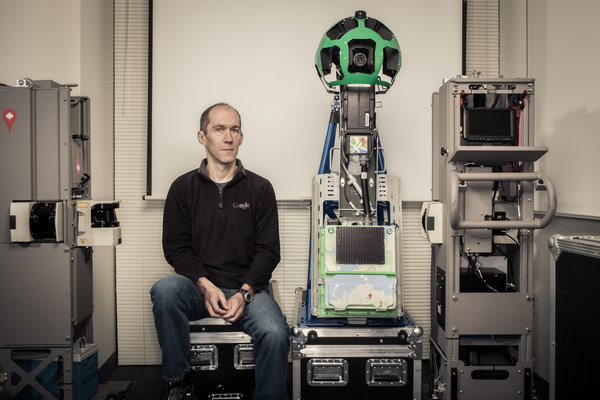
I was seated in the front of the lead raft. Pole position meant taking a dunk through the rapids, but it also put me next to Luc Vincent, the expedition’s leader. Vincent is the man responsible for all the imagery in Google’s online maps. He’s in charge of everything from choosing satellite pictures to deploying Google’s planes around the world to sending its camera-equipped cars down every road to even this, a float through the Grand Canyon. The raft trip was a mapping expedition that was also serving as a celebration: Google Maps had just introduced a major redesign, and the outing was a way of rewarding some of the team’s members.

Vincent wore a black T-shirt with the eagle-globe-and-anchor insignia of the United States Marine Corps on his chest and the slogan “Pain is weakness leaving the body” across his back. Though short in stature, he has the upper-body strength of an avid rock climber. He chose to get his Ph.D. in computer vision, he told me, because the lab happened to be close to Fontainebleau — the famous climbing spot in France. While completing his postdoc at the Harvard Robotics Lab, he led a successful expedition up Denali, the highest peak in North America.

A Frenchman who has lived half his 49 years in the United States, Vincent was never in the Marines. But he is a leader in a new great game: the Internet land grab, which can be reduced to three key battles over three key conceptual territories. What came first, conquered by Google’s superior search algorithms. Who was next, and Facebook was the victor. But where, arguably the biggest prize of all, has yet to be completely won.

Where-type questions — the kind that result in a little map popping up on the search-results page — account for some 20 percent of all Google queries done from the desktop. But ultimately more important by far is location-awareness, the sort of geographical information that our phones and other mobile devices already require in order to function. In the future, such location-awareness will be built into more than just phones. All of our stuff will know where it is — and that awareness will imbue the real world with some of the power of the virtual. Your house keys will tell you that they’re still on your desk at work. Your tools will remind you that they were lent to a friend. And your car will be able to drive itself on an errand to retrieve both your keys and your tools.

While no one can say exactly how we will get from the current moment to that Jetsonian future, one thing for sure can be said about location-awareness: maps are required. Tomorrow’s map, integrally connected to everything that moves (the keys, the tools, the car), will be so fundamental to their operation that the map will, in effect, be their operating system. A map is to location-awareness as Windows is to a P.C. And as the history of Microsoft makes clear, a company that controls the operating system controls just about everything. So the competition to make the best maps, the thinking goes, is more than a struggle over who dominates the trillion-dollar smartphone market; it’s a contest over the future itself.

Google was relatively late to this territory. Its map was only a few months old when it was featured at Tim O’Reilly’s inaugural Where 2.0 conference in 2005. O’Reilly is a publisher and a well-known visionary in Silicon Valley who is convinced that the Internet is evolving into a single vast, shared computer, one of whose most important individual functions, or subroutines, is location-awareness.

Google’s original map was rudimentary, essentially a digitized road atlas. Like the maps from Microsoft and Yahoo, it used licensed data, and areas outside the United States and Europe were represented as blue emptiness. Google’s innovation was the web interface: its map was dragable, zoomable, panable.

These new capabilities were among the first implementations of a technology that turned what had been a static medium — a web of pages — into a dynamic one. MapQuest and similar sites showed you maps; Google let you interact with them. Developers soon realized that they could take advantage of that dynamism to hack Google’s map, add their own data and create their very own location-based services.

A computer scientist named Paul Rademacher did just that when he invented a technique to facilitate apartment-hunting in San Francisco. Frustrated by the limited, bare-bones nature of Craigslist’s classified ads and inspired by Google’s interactive quality, Rademacher spent six weeks overlaying Google’s map with apartment listings from Craigslist. The result, HousingMaps.com, was one of the web’s first mash-ups.

Read the entire article here.

Image: Luc Vincent, head of Google Maps imagery. Courtesy of NYT Magazine.

Citizens and Satellites: SkyTruth

Daily we are reminded how much our world has changed and how it continues to transform. Technology certainly aids those who seek to profit from Earth’s resources, as they drill, cut, dig, and explode. Some use it wisely, while others leave our fragile home covered in scars of pollution and exploitation — often unseen.

For those who care passionately about the planet, satellite surveillance has become an tool essential tool — in powerful yet unexpected ways.

From the Washington Post:

Somewhere in the South Pacific, thousands of miles from the nearest landfall, there is a fishing ship. Let’s say you’re on it. Go onto the open deck, scream, jump around naked, fire a machine gun into the air — who will ever know? You are about as far from anyone as it is possible to be.

But you know what you should do? You should look up and wave.

Because 438 miles above you, moving at 17,000 miles per hour, a polar-orbiting satellite is taking your photograph. A man named John Amos is looking at you. He knows the name and size of your ship, how fast you’re moving and, perhaps, if you’re dangling a line in the water, what type of fish you’re catching.

Sheesh, you’re thinking, Amos must be some sort of highly placed international official in maritime law. … Nah.

He’s a 50-year-old geologist who heads a tiny nonprofit called SkyTruth in tiny Shepherdstown, W.Va., year-round population, 805.

Amos is looking at these ships to monitor illegal fishing in Chilean waters. He’s doing it from a quiet, shaded street, populated mostly with old houses, where the main noises are (a) birds and (b) the occasional passing car. His office, in a one-story building, shares a toilet with a knitting shop.

With a couple of clicks on the keyboard, Amos switches his view from the South Pacific to Tioga County, Pa., where SkyTruth is cataloguing, with a God’s-eye view, the number and size of fracking operations. Then it’s over to Appalachia for a 40-year history of what mountaintop-removal mining has wrought, all through aerial and satellite imagery, 59 counties covering four states.

“You can track anything in the world from anywhere in the world,” Amos is saying, a smile coming into his voice. “That’s the real revolution.”

Amos is, by many accounts, reshaping the postmodern environmental movement. He is among the first, if not the only, scientist to take the staggering array of satellite data that have accumulated over 40 years, turn it into maps with overlays of radar or aerial flyovers, then fan it out to environmental agencies, conservation nonprofit groups and grass-roots activists. This arms the little guys with the best data they’ve ever had to challenge oil, gas, mining and fishing corporations over how they’re changing the planet.

His satellite analysis of the gulf oil spill in 2010, posted on SkyTruth’s Web site, almost single-handedly forced BP and the U.S. government to acknowledge that the spill was far worse than either was saying.

He was the first to document how many Appalachian mountains have been decapitated in mining operations (about 500) because no state or government organization had ever bothered to find out, and no one else had, either. His work was used in the Environmental Protection Agency’s rare decision to block a major new mine in West Virginia, a decision still working its way through the courts.

“John’s work is absolutely cutting-edge,” says Kert Davies, research director of Greenpeace. “No one else in the nonprofit world is watching the horizon, looking for how to use satellite imagery and innovative new technology.”

“I can’t think of anyone else who’s doing what John is,” says Peter Aengst, regional director for the Wilderness Society’s Northern Rockies office.

Amos’s complex maps “visualize what can’t be seen with the human eye — the big-picture, long-term impact of environment damage,” says Linda Baker, executive director of the Upper Green River Alliance, an activist group in Wyoming that has used his work to illustrate the growth of oil drilling.

This distribution of satellite imagery is part of a vast, unparalleled democratization of humanity’s view of the world, an event not unlike cartography in the age of Magellan, the unknowable globe suddenly brought small.

Read the entire article here.

Image: Detail from a September 2012 satellite image of natural gas drilling infrastructure on public lands near Pinedale, Wyoming. Courtesy of SkyTruth.