
Who or what has been moving these Death Valley boulders? Theories have persisted for quite some time: unknown inhabitants of the desert straddling California and Nevada; mischievous troglodytes from Middle Earth; aliens sending us cryptic, geologic messages; invisible demons; telepathic teenagers.
But now we know, and the mysterious forces at work are, unfortunately, rather mundane — the rocks are moved through a combination of rain, ice and wind. Oh well — time to focus on crop circles again!
From ars technica:
Mario is just a video game, and rocks don’t have legs. Both of these things are true. Yet, like the Mario ghosts that advance only when your back is turned, there are rocks that we know have been moving—even though no one has ever seen them do it.
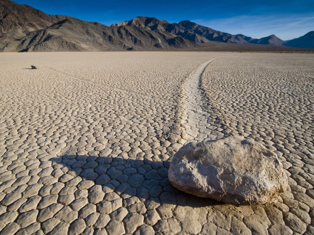
The rocks in question occupy a spot called Racetrack Playa in Death Valley. Playas are desert mudflats that sometimes host shallow lakes when enough water is around. Racetrack Playa gets its name from long furrows extending from large rocks sitting on the playa bed—tracks that make it look as if the rocks had been dragged through the mud. The tracks of the various rocks run parallel to each other, sometimes suggesting that the rocks had made sharp turns in unison, like dehydrated synchronize swimmers.
Many potential explanations have been offered up (some going back to the 1940s) for this bizarre situation, as the rocks seem to only move occasionally and had never been caught in the act. One thing everyone could agree on was that it must occur when the playa is wet and the muddy bottom is slick. At first, suggestions revolved around especially strong winds. One geologist went as far as to bring out a propeller airplane to see how much wind it would take.
The other idea was that ice, which does occasionally form there, could be responsible. If the rocks were frozen into a sheet of ice, a little buoyancy might reduce the friction beneath them. And again, strong winds over the surface of the ice could drag the whole mess around, accounting for the synchronized nature of the tracks.
Over the years, a number of clever studies have attempted to test these possibilities. But to truly put the question to rest, the rocks were going to have to be observed while moving. A team led by Richard Norris and his engineer cousin James Norris set out to do just that. They set out 15 rocks with GPS loggers, a weather station, and some time-lapse cameras in 2011. Magnetic triggers were buried beneath the rocks so that the loggers would start recording when they began to move. And the Norrises waited.
They got what they were after last winter. A little rain and snow provided enough water to fill the lake to a depth of a few centimeters. At night, temperatures were low enough for ice to form. On a few sunny days, the rocks stirred.
By noon, the thin sheet of ice—just a few millimeters thick—would start breaking up. Light wind pushed the ice, and the water in the lake, to the northeast. The rocks, which weren’t frozen into the thin ice, went along for the ride. On one occasion, two rocks were recorded traveling 65 meters over 16 minutes, with a peak rate of 5 to 6 meters per minute.
These movements were detectable in the time-lapse images, but you might not actually notice it if you were standing there. The researchers note that the tracks carved in the mud aren’t immediately apparent due to the muddy water.
The total distances traveled by the instrumented rocks between November and February ranged from 15 to 225 meters. While all moving rocks travel in the direction of the prevailing wind, they didn’t all move together—motion depended on the way the ice broke up and the depth of the water around each rock.
While the proposed explanations weren’t far off, the thinness of the ice and the minimal wind speed that were needed were both surprises. There was no ice buoyancy lifting the rocks. They were just being pushed by loose sheets of thin ice that were themselves being pushed by wind and water.
In the end, there’s nothing extraordinary about the motion of these rocks, but the necessary conditions are rare enough that the results still shock us. Similar tracks have been found in a few playas elsewhere around the world, though, and ice-pushed rocks also leave marks in the shallows of Canada’s Great Slave Lake. There’s no need to worry about the rocks at Racetrack Playa coming to life and opening secretly ferocious jaws when you look away.
Read the entire story here.
Image: Rocks at Racetrack Playa, Death Valley. Courtesy of Arno Gourdol. Some Rights Reserved.


